The Wye Valley Railway
1866 Scheme
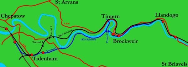
The original WVR route south
of Llandogo was somewhat different to the eventual alignment,
which was only adopted in the 1870s and would not have been built
if the line had been completed promptly after obtaining its Act
of Parliament. It is marked out in black on the map above (where
north is to the right).
Perhaps of most note is that
this route would have seen the line spend less than 1,000 yards
underground. (A tunnel through the meander north of Tintern would
have made it a straighter route at the expense of requiring a
third expensive tunnel, so the proposal went for some extra bends
instead. Trains ran more slowly in the 1860s, so bends were less
of a concern than they are now.) Other effects of the alteration
included a lengthening of the bridge over the Wye, which was
to be 60 yards long rather than the 67 that was required at Tintern.
Gradients were to be varied slightly, with 1½ miles of
1 in 86 climbing from the Wye Bridge (rather than the 1 in 66
for just over a mile from Wye Valley Junction to Tidenham Tunnel)
followed by a mile of 1 in 71 down to the Wye (rather than descending
at 1 in 90 and 1 in 100 to Brockweir). The railway would then
rise gently up the hillside to pass around the Tintern meander
above the village before plunging steeply back to river level
on a falling gradient of 1 in 75; the eventual scheme eliminated
the tighter curves at the expense of the local traffic and had
to build a branch line with an additional river crossing which
would have been unnecessary had the railway been laid out on
the 1866 route.
The chord running south from
Tidenham was to link into the South Wales and Great Western Direct
Railway - which planned to cross the River Severn into England
at this point, but never did.
Had the line been built, Tintern
station would have been built within Tintern itself, although
Tidenham would most likely still have been built in its cutting
above the A48 (where the two alignments converge briefly and
the levels proposed are largely similar, the longer run down
to the mainline with the earlier route being explained by the
easier gradient). A halt would have very likely still gone in
at the south portal of the first tunnel in the 1930s, but it
would have been able to serve the larger population at Woodcroft,
on the St Briavels road, rather than the scattering of houses
around the eventual halt on Netherhope Lane. A halt could also
conceivably have been built to serve St Arvans at the north end
of the railway's bridge over the Wye, but it wouldn't have had
road access so such a development would have been unlikely.
The 1866 scheme runs around
the outskirts of Livox Quarry on the west bank of the river in
that meander just north of its river crossing, mirroring Tintern
Quarry on the east bank which the 1875 scheme skirts and served
well. Livox lasted much longer than Tintern - it wasn't visible
from the road and wasn't digging up Offa's Dyke - and perhaps
the railway would have similarly survived another 25 years for
stone traffic had it run that way. Equally, the quarry owners
might have been more willing to lose the railway when they could
transport the stone out with greater ease by road than was possible
at Tintern Quarry, which is built into a steeper hillside. To
exploit Tintern Quarry it would have been necessary to provide
a conveyor belt across the river, which would have also allowed
stone from that quarry to be transported by road if rail costs
became excessive. And excessive they would have become, since
the bridge over the Wye at Livox would have had much the same
problems as that at Tintern, except it would have had to be repaired
to allow the stone traffic to continue.
On the other hand, while a
station in Tintern wouldn't have generated enough traffic in
itself to save the line, the output of two quarries together
might have made it worthwhile rebuilding the bridge for heavy
stone traffic, thereby justifying retaining the railway for the
passenger traffic until such time as it became politically undesireable
to axe rural branch lines. Perhaps... it's still a rather optimistic
version of events for a line which certainly wouldn't have been
any faster than that which was built and so would probably still
have quietly disappeared in the 1959 round of closures. If passenger
traffic had survived 1959 then the only result would have been
that Appendix 2 of the Beeching Report would have included all
the WVR stations and the line would have closed to all traffic,
rather than just goods, in 1964.
The pictures below give a
rough idea of the alignment of this proposed route and how it
would have fitted into the landscape.
|
Wye Valley Junction
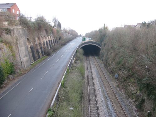
|
Chepstow Tunnel was
built in the late 1980s when the A48, seen at left, was brought
across the Wye alongside the railway in order to bypass the old
awkward passage through the town centre, with its narrow roads,
restrictive medieval town gate and early 19th-century river bridge.
The new road wanted a link into the suburbs on the English bank
of the river, so it climbed sharply away from the railway, put
the railway in a tunnel and built the road junction over the
tunnel. The road then curves away to the north to pick up the
old alignment of the A48 and the railway emerges from its tunnel
for Wye Valley Junction.
However, had the WVR been
built to its 1860s scheme the rail junction would not have been
at the far end of the tunnel but here, with the Monmouth-bound
track climbing up where the bushes down the centre of the picture
are and requiring the road to climb even more sharply to successfully
enclose it. Alternatively the rail junction could have been moved
to its current location and the steeper incline imposed to avoid
clashing with the road; the two alignments meet at Tidenham station
anyway. But by the late 1980s it would probably have been deemed
simpler just to shut the quarry branch and the prospects of reopening,
with the first quarter of a mile obliterated, would be bleaker
than ever.
Before the tunnel was built,
the railway ran down a narrow rocky cutting here, with the wall
on the right hand side being mirrored to the left of the railway.
It was then possible to see right down the cutting to Tutshill
Halt, Wye Valley Junction and the point where the mainline eventually
curves slightly to the north to follow the banks of the Severn
to Lydney. |
|
Tidenham station
|
Tidenham station is
something of a fixed point in the history of the WVR; except
for its short period of closure in 1917, the little single-platform
station, set in a slight cutting in the hillside above the A48,
has been a location of note since the 1866 Act went through.
It was the only point on the line between Chepstow and Llandogo
to remain completely unchanged when the line was redrawn in the
early 1870s, although the gradient on which the station is built
was steepened slightly during proceedings.
The station roughly marks
the point where the railway crosses the old Roman Road which
is now the A48, so a stop would most certainly have been planned
for here on the original plan. Whether or not it would have exactly
resembled the station that was built is debatable. Nicely decorated
with standard Great Western Railway trees, the station has survived
the years of closure better than most and the location is still
clearly visible today. Uniquely among all of the intermediate
points of interest featured on this page, it has seen construction
work, rails and trains. Nowadays it is decorated with rubble,
buddleia and a familiar dead trailer, but it remains - for now
anyway - a rail-linked station, as intended in 1866.
(It should probably be noted
that, since the route was only changed south of Llandogo, the
stations at Bigsweir/ St Briavels and Redbrook would have also
been built in the same place under the 1866 scheme.) |
|
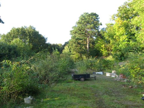
Woodcroft Tunnel (South
Portal)
|
Woodcroft Tunnel South
Portal was to be located in the field shown left at the bottom
of a deep cutting. Having curved away from the line which was
actually built, the proposed route reversed its gradient and
fell steadily towards Tintern, although strictly speaking at
this point it was running west rather than north. This was a
circuitous route.
In the distance, along the
skyline, is Woodcroft. It is an attractive sort of place and
had the line been built along this route it would probably have
obtained a halt at about the time that Netherhope was built.
However, the halt would have been some way from Woodcroft and
there is no road in the vicinity. It would also have been thoroughly
unpleasant, being located at the bottom of a 50ft deep rocky
cutting by the mouth of a 712yard tunnel. Netherhope Halt was
fortunate to be built at the bottom of a steep hill, allowing
it to be situated in an attractive little cutting despite the
line soon finding itself far enough below ground level to justify
a tunnel. |
|
Wintour's Leap
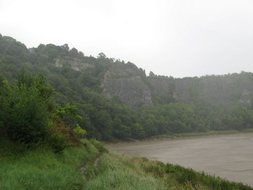
|
Royalist Sir John de
Wintour is said to have given his name to Wintour's Leap when
he made his horse carry him over it during the English Civil
War. It was a great way to escape pursuing Parliamentarians,
who didn't have quite the same frame of mind and instead left
him and his horse to paddle down the Wye to Chepstow, where they
were presumably fished out and taken into the Royalist-held castle
for protection.
Since then the Leap has not
actually featured much in general points of exciting news, although
the B4228 St Briavels to Chepstow road has a delightful blind
bend at the top of a particularly high point of the cliff where
traffic approaching from St Briavels at excess speed is protected
from one of the finer deaths available on the British road network
by a rickety overgrown fence and a minimal crash barrier. Oddly
nobody appears to have exercised their right to be killed this
way recently. The Leap has also been subjected to some general
quarrying efforts which have left it slightly further back from
the river than it was in de Wintour's time.
The WVR was going to have
the Woodcroft Tunnel emerge partway down this cliff on the right
of this view (taken, regrettably, on one of the occasions in
the Wye Valley when it rains). The railway would then run down
the hillside before plunging into another tunnel on the left,
which would have carried it through one of the Wye's periodic
meanders into the next length of the valley.
This is a particularly attractive
point on the valley and it is in many respects a shame that the
railway never came this way. However, it may also be this point
which finished it off, due to the awkwardness of bringing the
railway out of a sheer cliff at an angle and then running it
along the side of said cliff without falling into the river,
which runs close to the rock face. |
|
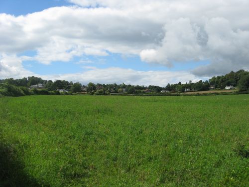
Livox
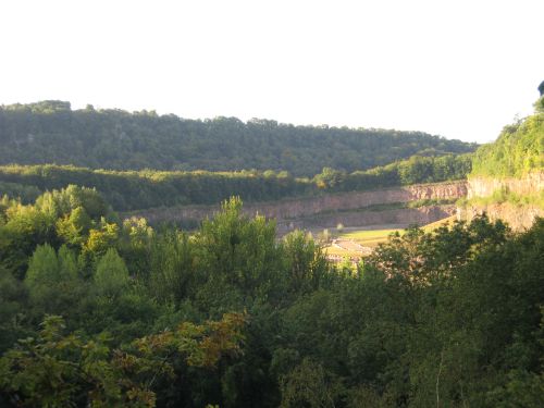
|
Livox Quarry survived
somewhat longer than Tintern Quarry; the fact that its exit didn't
depend on a lightly-maintained elderly railway tunnel meant that
it survived the 1980s and only closed comparatively recently.
It is seen here in September 2010; in January of the previous
year it had still been filled with bits of (slightly derelict)
quarry equipment. Efforts are now being made to landscape it
- unlike Tintern, which is gradually landscaping itself and will
perhaps eventually look all the better for it.
The farthest wall of the quarry
backs onto a ridge, with the morning sun marking out the summit
as it pours down the other side. Behind the ridge is the Wye
- this design ensures that those on the river can't see straight
into the quarry and we can't see the Wye. The background hill
is on the other bank of the Wye (though, due to the way in which
the Wye twists around, it is in fact the same bank as the one
that this picture was taken from). The 1866 WVR intended to burst
from this hill, cross the river, turn to its right and run around
the bottom of the quarry to the left of this picture. It would
then pass across the middle of the view (hidden behind the trees)
and head off to the right towards Tintern.
The 1875 WVR, as built, was
used as a standing point for taking this picture, with its view
across the Wye from a fine embankment across the railway. |
|
Tintern
|
The original line was
to take a rather central course through Tintern; had it been
built then there would be little possibility of being able to
pass through the village without noticing that it once had a
railway. This would probably be balanced by a reduced liklihood
of the line reopening brought on by someone deciding in the 1970s
that the station would make a lovely secluded site for a small
housing estate.
This picture was taken from
a location close to the point where the Wireworks Branch of the
constructed line crossed the A466 on its way to the Angiddy wireworks.
The Angiddy is below the foreground fence and the wireworks are
less than quarter of a mile away to the right. The Wye is off
to the left and the camera is pointing towards Chepstow.
The exact proposed location
of the station is unclear. It would have been based on a compromise
between operational convenience (which would dictate a location
halfway between Tidenham and Bigsweir) and construction convenience
(which would dictate a location where it is possible to build
a three-platform station and goods yard without having a 50ft
cliff above and a 50ft retaining wall below). This compromise
would have either dictated a location at the north end of the
village or on the flank of the background hill, with the station's
northern throat being located around the particularly tall tree
in the centre of the image. This location is more likely, being
fairly convenient for the Angiddy wireworks and Tintern Abbey;
neither is more than a few hundred yards away, which is more
than can be said for the eventual station site. This location
would have been 5 miles from the junction; the eventual station
was 4½ miles, but that's as much down to the junction
being moved as a shorter route.
The valley was then to be
crossed by a 50ft-high embankment, with bridges for the road
(between the houses) and a tramway (which presumably subsequently
became part of the Wireworks Branch). |
From Tintern station, the
line was to run around the hillside and rejoin the current alignment
a little to the north of Brockweir.
While the WVR may perchance
one day re-open, the prospects of this alignment being built
are nil. It is not entirely clear why it was decided to change
course. Perhaps the demise of the South Wales and Great Western
Direct Railway led to a re-assessment of the route. From a construction
point of view it is the superior railway; the west bank of the
Wye is largely more gently sloping than the east and Tidenham
Tunnel is a massive work of engineering which would simply not
have been necessary for the 1866 route. However, there are three
things which went against this alignment:
- The railway was to pass through
Tintern station rather too close to the Abbey; the later route
preserved its picturesque appearance;
- The two tunnels were on a
gradient of 1 in 71; the later route offered a gentler gradient;
- The Wye was likely to have
to be marginally diverted at Wintour's Leap to provide the necessary
room for the planned alignment.
Perhaps it was a decision
based on these three points which sealed the fate of this scenic
little route before the first shovel of earth had even been turned.
<<<Wye
Valley Railway<<<
30/09/10 |