The Monnow Valley
Railway
Monmouth - Skenfrith
- Pontrilas
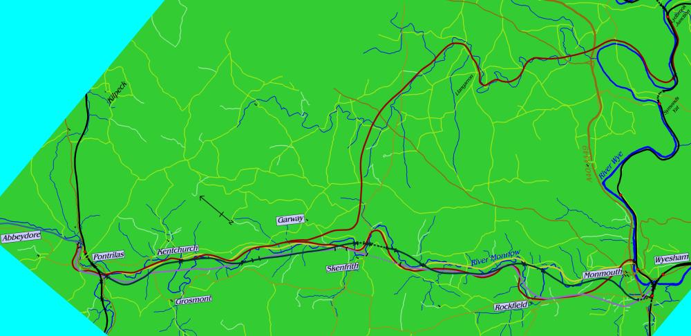 The 1860s scheme is the dark green line between
Monmouth and Pontrilas, while the 1883 one is represented by
a purple line. The dark red lines are the 1888 scheme and the
yellow line is the 1889 scheme. Primary roads are in red, secondary
roads in orange, minor roads in yellow, very minor ones in white,
other railways in black and rivers in blue. Any stations which
you may be able to pick out are shut.
As railways go the MVR left
a great deal to be desired - the principal thing on the "To
organise" list being a railway. Two companies proposed links
between Monmouth and Pontrilas up the attractive Monnow Valley
and neither succeeded in organising anything much.
First up was an 1860s project,
which appears to have been principally driven by its contractor
Thomas Savin. It proposed a route with three tunnels - one at
Monmouth and two at Skenfrith - and nine major river crossings
- too many to list the locations of or, indeed, for any reasonable
railway to afford. It announced plans to work with the Coleford,
Monmouth, Usk and Pontypool Railway - then the only railway serving
Monmouth - to develop what would later be known as Troy station
as the junction at the south end of the route. It would have
been a rather unusual junction, with at least three and possibly
four platforms built around lines bursting out of tunnels in
an impressive manner on the western side of the site and dropping
to a single freight-only line (climbing over a viaduct and across
the Wye to Wyesham Wharf) on the eastern side of the site. The
single-track line would have provided an outlet for Forest of
Dean traffic to the North - a long-running ambition of the era
- since at the Pontrilas end it was to form a junction with the
Newport, Abergavenny and Hereford Railway.
Work began in 1866, shortly
after two more railways to Monmouth (from Ross to the north and
Chepstow to the south) had been approved, and the odds looked
rather good on Monmouth having four railways by the end of the
decade. However, Savin had been spending the previous few years
overstretching himself with heavy investments in his fleet of
railways, of which the Monnow Valley was a fairly typical example
- it ran through a hilly area of sparse population with lots
of expensive earthworks en route. Indeed, the only point
on which the Monnow Valley differed from its fellows was that
it was under 30 miles long. It therefore shouldn't have come
as too much of a surprise to too many people when Savin went
to the wall within weeks of beginning work on Monmouth's new
railway tunnel. The tunnel probably wasn't to blame for his bankruptcy
- a more likely cause is his other project, the Mid-Wales Railway,
which had just been completed at considerable expense to link
up various isolated bits of Wales where very few people lived
and industry was largely unknown.
Soon after any prospect of
recovering the works and continuing the project were destroyed
by the collapse of the Overend and Gurnley merchant bank - the
last run on a bank until Northern Rock in 2007 and brought on
by a crisis about the ability of its debtors to pay after a failed
claim against the Mid-Wales Railway - and the ensuing economic
recession, which also nearly killed the lines from Ross and Chepstow
into the bargain. The Wye Valley Railway's eventual arrival from
Chepstow was soon followed by bright ideas about the high probability
of recommencing work on the line, which probably didn't please
any of the three complete railways very much since their tidy
Monmouth terminus was still marred by the incomplete (but rather
large) hole in the wall of the approach road which was supposed
to have become a railway tunnel for the last attempt.
However, it was equally now
undeniable that a line from Monmouth to Pontrilas would make
a very useful outlet for Forest of Dean traffic to the North,
since the outlet which had ultimately been provided allowed trains
from the Severn and Wye Railway network in the Forest to join
the Ross and Monmouth Railway at Lydbrook - pointing south and
towards Monmouth, which wasn't exactly the direct outlet wanted.
An alternative was provided with a steeply-graded route between
Mitcheldean (on the cross-country line between Hereford and Gloucester)
and Cinderford (the northern nucleus of the Forest network) a
couple of years later, but that went on to show that just because
someone built a railway didn't mean that they were under any
obligation to call in the Board of Trade and obtain permission
to run trains over it. They could just leave it to rust away
instead. Which they did.
So the 1880s dawned with no
direct link from the Forest of Dean to the North - although since
the junctions at Lydney, Awre and Bullo all pointed in a vaguely
northerly direction, even if they were at the southern end of
the Forest, one does have to wonder why there had over the years
been so much fuss over it - and so a new project emerged. In
fact it emerged three times over the decade, with various developments
and alterations on each occasion which converted it from being
an upmarket through line to a twisting chord of no real importance.
It was to be built as part of a through line to Hay-on-Wye -
the Golden Valley Railway was planning to link Pontrilas with
Hay and thought that a southwards extension to Monmouth would
be a useful connection to help boost their railway's credentials.
(Their prospectus suggested that their line would form part of
a direct link between Liverpool and Bristol. The bulk of the
100-mile route was to single track, with steep gradients and
a maximum speed of 40mph. Bits of it hadn't been built yet.)
Hay was already served by
the Hereford, Hay and Brecon Railway (another of Thomas Savin's
jobs). Done correctly, the cross-country line from Monmouth to
Hay could have given Hay some status as a railway junction, although
since Forest industry wasn't doing exceptionally well and there
was no industry or population to speak of en route there
was no reason as to why it should have particularly flourished.
In the event it never had the opportunity to flourish. The line
from Pontrilas to Hay was an unmitigated failure from opening
throughout in 1889 (it had managed to open part-way in 1881 and
then struggled to even afford a begging bowl to raise the cash
to cover the rest) and never found the money - despite its management
having the inclination - to extend to Monmouth. In 1898 all services
ceased - almost faster than a typical Golden Valley train
- although in 1901 - after three years out of commission - the
Great Western Railway reopened the route and ran it as a public
service. In summer 1935 trains were leaving Hay empty and passenger
loadings rarely scraped into double figures. It closed "for
the duration" (of the Second World War) in 1941 and was
eventually dismantled in 1957 after reopening was decided to
be unlikely.
The villages of Rockfield,
Skenfrith, Garway, Grosmont and Kentchurch therefore never got
their much hyped railway and instead got to watch on with interest
as Abbeydore, Bacton, Peterchurch and Dorstone went through the
unenjoyable experience of being served by a transport company
with barely sufficient funds to buy the next day's coal for the
locomotive. The railways mentioned in this story almost all proceeded
to close - the Severn and Wye began to vanish in 1929 and little
remained after 1956 (although the Dean Forest Railway has preserved
six miles); the Monmouth to Pontypool line mostly shut in 1955
and Monmouth lost all passenger trains when its other two branches
closed in 1959. The Hereford, Hay and Brecon closed in 1963 and
Pontrilas station closed in 1964, a few months after goods traffic
to Monmouth had ceased. The Newport, Abergavenny and Hereford
largely survives today.
The series of pictures below
follow the route proposed in the 1860s; below them is a sequence
on the 1880s lines.
|
Monmouth Troy
|
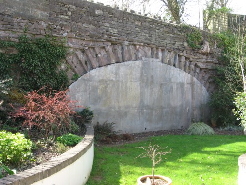
Thomas Savin's decision to
build a new tunnel for his line to leave Monmouth Troy station
through made a certain amount of sense; the tunnel that was already
there pointed in the wrong direction and another expensive tunnel
would have been required to allow the new line to pass out of
the Trothy valley used by the Pontypool line into the Monnow
valley to be used by the Pontrilas route. Monmouth Troy was less
than ten years old at the time and bore little resemblance to
the familiar station of the 20th century, which was largely the
result of the late 19th century modernisation of the Coleford,
Monmouth, Usk and Pontypool Railway. Intriguingly, the only section
of the entire line to be built - this tunnel - is not on the
deposited plan, which infers that a cutting was planned instead.
The bore was intended to be
a short double track tunnel cutting through a low flank of the
Gibralter Rock and made a good point at which to start construction
of the line. Thus the Monnow Valley became the second railway
at Monmouth Troy station. Soon after it gained the indignity
of being placed on the list of "Incomplete Railways"
alongside such commercial successes as the Forest of Dean Central
Railway, although that at least got to operate a few trains over
the line that it built. The only use ever found for this tunnel
- which was only a score or so yards long, if that - was as the
station store. Its historic importance as the last piece of railway
infrastructure begun by Thomas Savin and the only feature of
the Monnow Valley Railway was probably largely ignored when squeezing
the station lorry around boxes to park it just inside the tunnel
portal at nights.
Later lorry designs were too
big to fit in the tunnel and it fell into disuse. In the 1970s
its proposed course was sliced into little pieces by the arrival
of the A449/A40 dual carriageway from Newport. At some point
around this time it was attractively sealed up completely with
a concrete wall. A 2002 housing development parked it squarely
in the back garden of a private house whose owners have attempted
to decorate the sulking arch with attractive garden plants. It
is at least no longer suffering the indignity of being used as
a storage space when it was intended to be a glorious transport
link, although at least in those days it had some purpose in
life.
Credit is due to the owners
of said private house for kindly allowing us to take the tunnel's
picture. It is the only piece of railway infrastructure you will
see on the line until we reach Pontrilas. |
|
West Monmouth
|
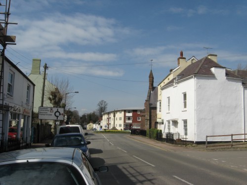
Once out of Monmouth Tunnel
the line climbed slowly around the back of Monmouth and crossed
the Rockfield Road just to the west of Monmouth's gated bridge.
The 1860s scheme proposed an easy gradient of 1-in-582 for this
stretch, with a 16ft high arched bridge. The ruling gradient
was a length of 1-in-123 between Monmouth and Rockfield - this
was to be a gently-graded line offering few challenges to even
the locomotives of the era.
Putting this into the context
of the photograph - which naturally shows no traces of the bridge
or associated property demolition since the plans never left
the proverbial drawing board - the gated bridge is behind the
white house to the right (it is now the No Through Road indicated
on the roundabout sign to the left). The railway would have passed
through the far end of the fine bit of 1960s architechture on
the far side of the roundabout, with the bridge suitably skewed
so that the right-hand abutment was a little closer to Rockfield.
None of the plans provide
station or junction layouts and instead make do with showing
where the single pair of rails were essentially planned to run.
Therefore it is not possible to conclusively say, based on the
initial plan, whether or not there would have been a station
around here. The answer is probably that there wouldn't have
been however; had it not been for the Ross and Monmouth's financial
problems, Monmouth would quite likely have had to make do with
Troy as the railhead until the 1930s. That does, however, mean
that in an incredibly roundabout and indirect way the Monnow
Valley may have improved Monmouth's transport links. |
|
Tregate Bridge

|
Open country, being open,
features few landmarks of note to identify precisely where a
railway would have run from a plan interested solely in the railway
and the surrounding 20 yards of land. Guesses can be made from
nearby farms and roads. It would seem to be a fairly good approximation
that if the railway had been built it would have come up from
Monmouth and Rockfield through the sparse line of trees in the
centre, straight through where the sheep are grazing, across
the road about where the picture was taken from and thence up
the valley towards Skenfrith.
The road from which the picture
was taken is that to the south-west of the "R" in "River
Monnow" on the map at the top of the page.
One of the striking things
about exploring unbuilt railways is that you are in essence seeing
the ground as it was before the railway was built. Had events
taken a different turn the sheep would probably not be grazing
on a level field but on the side of a slightly raised track.
The photograph would have been taken from a fine arch bridge
about 20ft off the ground. Instead we have an attractive and
largely untouched rural scene which has changed little over the
century since the line was proposed. |
|
East of Skenfrith
|
Skenfrith was to feature the
most impressive bits of infrastructure, including two tunnels,
so hopefully you'll forgive a lengthy pause here. Approaching
Skenfrith from the south-west, the Monnow turns to the north-east,
runs around a promontory, heads west into Skenfrith and then
turns north around another promontory, before returning to a
Pontrilas-bound course.
These sudden changes of direction
were too much for the original railway scheme, which planned
to skip all of them and bypass Skenfrith in the process with
the help of three river crossings and two tunnels in the space
of a mile. Few railways ever planned such intensity of major
engineering features (the closest in the Monmouth area was the
Hereford, Ross and Gloucester, which kept the bridges at least
a mile apart) and they can't have done much in the way of encouraging
the local bigger companies to build it.
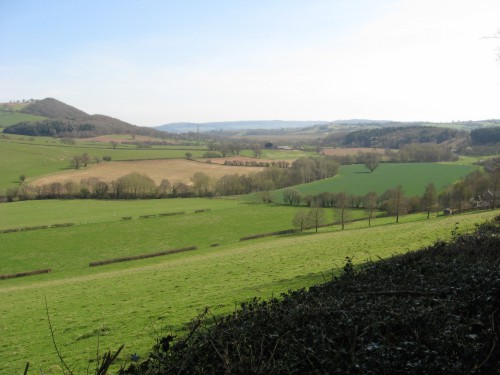
This picture looks down the
valley towards Monmouth. The river can be seen winding around
the valley in a belt of trees. The railway would have approached
across the brown fields in the centre. It was then going to cross
the river, pass across the two green fields on the centre left
and enter the a short cutting on this side of the avenue of trees
climbing up the foreground field towards the farm on the right.
The cutting would have swiftly ended in the first and longer
of the line's two tunnels. The proposed styling of the tunnel
is unknown. |
|
Skenfrith

|
The hill through which the
longer Skenfrith Tunnel would have passed is crossed by a rather
minor lane, from which both the previous picture and this one
were taken. This picture looks towards Pontrilas; the river is
hidden behind the bank of trees across the centre. Skenfrith
is off to the left. The second promontory dominates the view;
Pontrilas is a few miles to the north behind it.
The railway would have emerged
from this hillside below the trees in the foreground, probably
in about the centre of this image. Almost immediately it would
have crossed the river on a short viaduct. After the river is
a narrow field; then comes the Skenfrith to Garway road; once
that was cross the railway would have plunged into the shorter
of its two tunnels.
The proposed location of Skenfrith
station is not marked. Here would have been the most convenient
point in relation to Skenfrith but the site would have been quite
tight and largely unsuitable. Stations were rarely built on bridges.
The other end of both tunnels is getting a little more remote
from Skenfrith, but to the north of the second tunnel and the
third river crossing would have been a possibility (albeit lacking
in road access, that area genuinely being all fields).
Of course, it is possible
that the promoters envisaged a through route with no intermediate
stops, but they were not very common on the whole and most railways
built in the 19th century provided stops at frequent intervals,
partly to appease the locals and partly to provide passing loops
(useful on single track lines). Stations purporting to serve
Skenfrith and Grosmont would therefore have ultimately been likely,
even if they were omitted from the map. |
|
West of Skenfrith
|
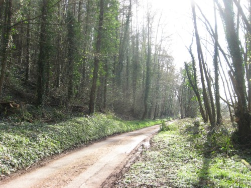
At the north end of the second
tunnel the line was to cross this attractive minor lane and then
immediately hurl itself out over the river, which is just on
the other side of the trees to the right. It was to have climbed
steadily all the way through the tunnels and over its three river
crossings; on the other bank of the river is a low promontory
pointing into the next meander which the railway would probably
have been able to pass over without having to cut into too deeply.
(The 1883 plans had the line staying on the valley floor and
a tunnel would therefore have been necessary to pass through
that meander. It would then have gone around the bottom of this
one, passing close to Skenfrith, and through a long tunnel to
pick up the Monnow again for the run down to Monmouth.)
All nine of the river crossings
on the 1860s plans were to feature single arch bridges with 60ft
spans, ranging between 10 and 20ft above river level. They would
have made a rather fine sight and it is something of a shame
that none were built for us to admire today. The low bridge across
this road that would also have been required would probably not
have been much of an impediment to the sort of traffic which
uses it.
The proposal with regards
to the tunnels was to drive cuttings into the hillsides until
they were 50ft deep and then begin boring the tunnels. Since
the hills are fairly perpendicular around here the resultant
cuttings would have been quite short. The cutting on departure
from Monmouth Troy was only expected to reach 46ft deep and so
would not require a tunnel. Why it was decided to bore one is
unclear. Since tunnels were rarely faced and lined until boring
was complete it is unlikely that the single tunnel portal built
for the line bears much resemblance to the planned appearance
for the tunnels up here (apart from the fact that it is a tunnel
portal and all tunnel portals have a certain familial resemblance). |
|
Grosmont for Kentchurch
|
The 1860s scheme was one of
these railways which saw a settlement of any particular size
and promptly bypassed it. This was, however, entirely because
the settlements weren't on a convenient through route between
Monmouth and Pontrilas - Skenfrith is at one extremity of
a meander and its fellow sizeable village in the area, Grosmont,
is at the top of a very big hill.
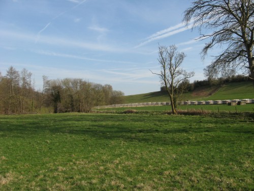
Therefore the railway cut
around the bottom of the hill and encountered the road from Grosmont
at Kentchurch, which is a very small hamlet on the north bank
of the Monnow with seven or eight houses and a pub. A farm on
the south bank has erected a fine line of covered pens along
a field boundary, roughly marking out where the railway would
have passed. Some road relevelling was anticipated.
It is not far from Grosmont
to Pontrilas and all four schemes had very similar ideas for
the last leg up the valley. On the final approach the Monnow
splits, with a tributary heading up into Pontrilas and the river
turning south towards Abergavenny. |
|
Pontrilas
|
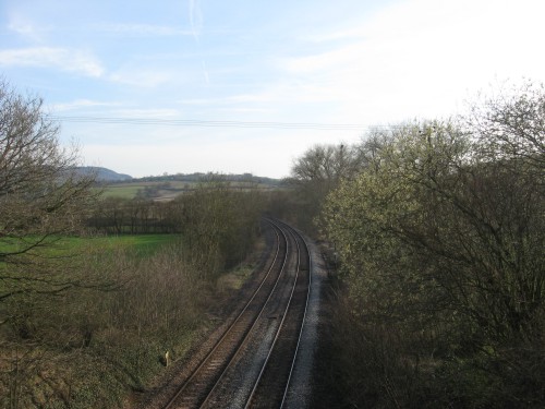
The Newport, Abergavenny and
Hereford Railway has always approached Pontrilas from the south
unencumbered by junctions. It opened in 1854 and provided the
backbone for a number of branchlines winding off across country
in various directions between Newport and Hereford. The bottom
end of the line south of Pontypool was subsequently replaced
by the Pontypool, Caerleon and Newport (which is still in use
today, although it now serves Cwmbran rather than Caerleon) but
the route is otherwise largely intact. Although the intermediate
stations have all been heavily rationalised (and largely closed)
the line is still covered by semaphore signals. Every single
one of the branches along the way has closed and - with the exception
of the Coleford, Monmouth, Usk and Pontypool Railway - lifted.
Thus it is statistically unlikely
that if the Monnow Valley Railway had been built it would still
be open today. (You may also wish to count the number of houses
in the pictures above too to get a rough idea of the sort of
passenger numbers that it might have obtained down the years.) |
Skenfrith returned to a proposed
railway map when Wells Owen and Elves, Engineers (of Westminster),
became involved in planning the South Wales and Forest of Dean
Junction Railway (generally abbreviated from hereon to the SW&FoDJR
to save space), which was to be submitted to Parliament in the
1877-8 session. It never actually was - perhaps someone pointed
out to the directors that a line with a fairly consistent gradient
of 1-in-40 in one direction or the other was not really practical
for heavy trains - so the plans for a line from Abergavenny to
Lydbrook via Skenfrith and Llangarron, with a branch to Ross-on-Wye,
were shelved. It was the sort of line for which the term "cross-country"
was invented. Its main aim was probably to allow Forest and Midlands
coal to be moved quickly and easily to Merthyr Tydfil and iron
and steel to be removed to the Midlands without requiring trains
to pass through Newport or wind around Hereford; the second half
of the journey, over the Heads of the Valleys line from Abergavenny
to Merthyr, wasn't really all that much better.
The 1880s saw the practically
bankrupt Golden Valley Railway decide that a Hay to Pontrilas
line was actually, on its own, going to be largely useless and
plans were put in hand for a link between Pontrilas and Monmouth.
The first scheme which was drawn up was presented to Parliament
during the 1883-4 session. This provided a series of differences
from the 1860s route:
- There was no connection into
Pontrilas station, so trains to Monmouth would have bypassed
the GWR station altogether by means of a 147-yard tunnel and
an avoiding line looping around the north and west sides of the
village;
- The straighter route would
require a second tunnel in the Kentchurch area;
- The line would have passed
around the outside of the main meander outside Skenfrith Castle,
allowing a decent station at Skenfrith and eliminating the shorter
Skenfrith Tunnel at the expense of building one to the north
of the village instead;
- The approach to Monmouth
would have resulted in a junction of remarkable size and expense,
with Troy station and the only extant earthworks being bypassed
to the north and the junction being built on the viaduct carrying
the Wye Valley Railway into Troy instead. Presumably the idea
was to connect with the GWR's Coleford Branch, then in the course
of construction.
- There were also various miscellaneous
realignments and gradient modificatios.
The Golden Valley was soon
reminded that its core aim was to link Hay and Pontrilas and
it had not actually yet achieved this. Its line petered out in
a field somewhere in rural Herefordshire, several miles short
of Hay. Such a railway should not be laying out plans to bore
1,684 yards of tunnel through lightly-populated low-industry
areas on the offchance that some through traffic might come its
way, so this one abandoned its expensive Monmouth scheme for
a bit and went back to raising money for lost causes.
In due course the 1887-8 Parliamentary
session saw the results of another survey of the area passed
up for authorisation after the Hay extension began to show some
signs of happening; there were four key differences from the
1860s route:
- The Pontrilas avoiding line,
as seen in 1883 and using a similar route, would allow Golden
Valley trains to pass Pontrilas without using Great Western metals
(although, unlike the 1883 plans, there would be a direct link
from Pontrilas station to the Monmouth line);
- The tunnels around Skenfrith
were replaced with a series of meanders, following the river
with the resultant tight curves;
- The rail network around Monmouth
was approached from the north, with a cutting under Monmouth
itself and the junction just north of May Hill station pointing
south, rather than using Troy station with an approach from the
west pointing east.
- A branch line from Garway
around Symonds Yat to Lydbrook was proposed, linking in to the
Severn and Wye network at Lydbrook Junction and featuring two
tunnels to make up for the loss of the ones around Skenfrith.
The GWR's Coleford Branch had been a flop due to its poor connection
with the Severn and Wye Railway at Coleford and the traffic which
would have been going that way was going via Lydbrook instead.
The engineers were the same
as the ones used by the SW&FoDJR, who appear to have taken
the opportunity to persuade the Golden Valley of the benefits
of using the surplus drawings for the Garway branch. There were
no practical benefits in terms of spare earthworks lying around
on the moors above Garway, since the SW&FoDJR hadn't actually
been incorporated and their only legacy was 16 pages of plans
detailing the proposed line. Some slight variations to the route
between Garway and Lydbrook were put in hand while the Skenfrith
to Abergavenny section and the Ross branch were both torn out
of the plans, but it was largely the 1877 route which the Golden
Valley incorporated as their proposed Railway No. 4 in the 1888
scheme.
Despite the curves and gradients,
the earthworks would remain quite impressive, with a viaduct
to cross the Ross and Monmouth Railway and the River Wye to the
east of Symonds Yat, several river crossings and a cutting under
Monmouth, which would have left a 50-foot deep trench under the
building which now houses the Nelson Museum. All-in-all the line
was going to cost a fortune to build and it is unlikely that
the Golden Valley managed to persuade many people to buy shares
in the route, particularly since it was already known that the
company was a basket case; certainly that would explain why the
Bill which was actually put before Parliament would appear to
have ditched the line between Garway and Lydbrook. (It also varied
the proposed route south of Skenfrith to largely run on the north
bank of the river.) The 1888-9 Parliamentary session featured
a new Golden Valley scheme which eliminated the Pontrilas avoiding
line as well, thereby reducing the scheme to a simple single
track chord with a siding to be installed at May Hill. This will
have had the benefit that the company could cut the amount it
was trying to raise in new share capital and the number of shares
that it was aiming to sell to raise this; once it had reached
the resulting much lower hurdle it could take out some large
loans to cover the remaining construction costs.
The lower hurdle doesn't seem
to have been reached either and the proposal was never heard
of again.
With the mainline from Pontrilas
to Monmouth largely covered above, the pictures below deal exclusively
with the proposed cross-country branchline from Garway down the
Garren Valley to pick up the Wye north of Symonds Yat, from where
the railway was to run to Lydbrook. The curvaceous line would
have passed through some very fine arable country and crossed
and re-crossed the Garren more times than is really decent. It
would also have annoyed pretty much every major landowner in
the area by slicing through their front gardens. Both versions
of the scheme will be considered, since there was not that much
difference between them.
|
Langstone Court
|
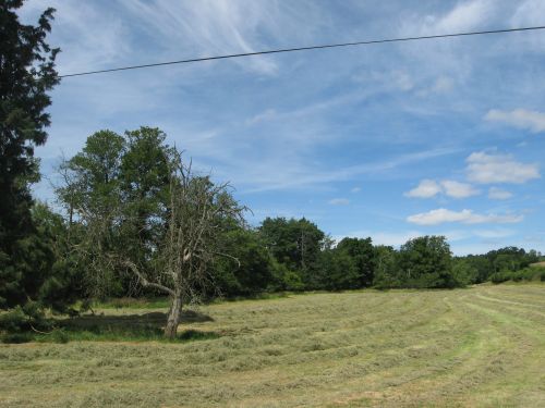
Langstone is home to a bridge,
a court (the country house variety) and not much else; the surrounding
landscape is typical of Herefordshire and its fertile nature
has clearly made the local landowner very rich (the staff get
rather comfortable houses adjacent to a large three-storey brick
manor house in expansive gardens). It was deemed to be the sort
of place that would like nothing better than a rail link; this
photo was taken from the middle of the proposed running line
at the point where it would have crossed the Langstone road.
Behind the camera to the left is Langstone Court; the green trees
running from the left into the centre of the view mark the Garren
Brook, which passes under Langstone Bridge. We are looking up
the line in the direction from which trains from Garway would
have appeared (due north; Garway itself is a few miles off to
the west. The railway was to meander around a bit).
Had the railway been built
and lasted into the 1930s, it would probably have obtained a
little wayside halt here. A full-blown station would have been
unlikely. The Golden Valley scheme was to run along the opposite
bank of the river to Langstone Court's front garden; the earlier
South Wales and Forest of Dean Junction Railway would have run
through the front garden and built its steeply-graded cross-country
line (aiming to carry lots of lovely black coal) straight across
the landowner's ornamental fish pond. Since the railway was never
built the front garden remains tidy and undesecrated, except
by a public footpath. |
|
Llangarron
|
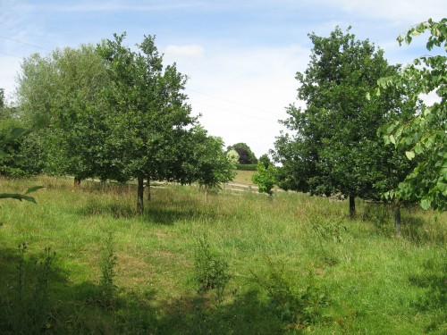
Llangarron is the only
decent settlement along the route that the railway was to pass
through; since it is roughly halfway along the 13¾ mile
line between Garway and Lydbrook and three-quarters of the way
along the 24¾ mile line from Abergavenny to Lydbrook it
is probably a pretty good bet that the village was intended to
get a station (even though it isn't marked on the plans for either
scheme). The proposed course of the railway past the village
is still largely unobscured and, helpfully, the point where it
would have crossed the road linking Llangarron to points east
and north is marked by farm gates on both sides of said road.
This is the view looking north into the most likely station area.
The village church is off to the left; running trains through
the station on a Sunday morning would have brought a whole new
meaning to the old complaint that railways working such services
were indulging in "desecration of the Sabbath".
Llangarron station - had it
been built by either scheme - would have entailed levelling this
attractive patch of land and building a suitable station building
with platform, loop line and goods yard on it. The SW&FoDJR
was proposing running through the station on a 1-in-59 gradient,
rising towards Lydbrook, which would carry the railway over the
road on a 25ft wide 15ft high arched bridge. A similar structure
would probably have been built by the Golden Valley Railway had
they ever come this way - which they didn't, so the road past
the church is still nice and open with no obstructions, barring
the odd tree, for 16ft high lorries. |
|
Symonds Yat
|
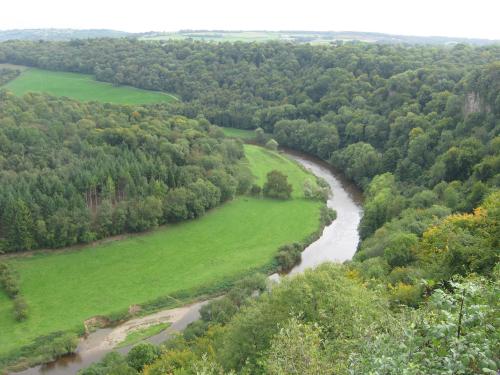
The railway then planned
to pass down the Garren Valley to pick up the River Wye; it would
the follow the Wye around the east side of Symonds Yat, from
where this photograph was taken. The views would have been quite
spectacular; while the view of the Yat from the Ross and Monmouth
Railway was always somewhat spoilt by the fact that the railway
passes through the bottom in a short tunnel, the line around
the side would have offered a view straight up the side of the
cliff from the bottom of the valley.
The line was to appear in
this picture in the field on the left. It would pass through
the gap about halfway up the hedge. It was to remain about halfway
up the field for most of the inside of that meander, but the
railway would curve slightly more gradually than the river. The
result was that the line would neatly cross both the river and
the adjacent Ross and Monmouth Railway, landing on the other
bank around the start of the field in the upper left of the picture.
The Ross and Monmouth Railway
ran around the outside of this meander, passing along the bottom
edge of the line of trees in the centre before plunging into
the trees and, eventually, its tunnel. |
|
South of Lydbrook
|
The approach to Lydbrook was
to be made by running along the hillside a little above the Ross
and Monmouth Railway, with the Wye below the train to the west.
Largely this stretch was to be level, with a slight rise at 1-in-66
over a ridge and a similar fall down the other side into Lydbrook
Junction. The Ross and Monmouth rises into the station, so the
line from Llangarron merely had to run level around the hillside
until the line below it caught up.
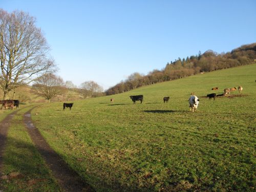
This is the field seen in
the upper left of the previous picture. The simple earthworks
along this stretch would have required a ledge to be cut into
the hillside somewhere around the location of the brown cows
to the right of the picture. The mud track around the left is
the remains of the Ross and Monmouth Railway. It left behind
one centre of population - at Symonds Yat - plus the tunnel,
a few miles of basic trackbed alongside the river and no major
bridges.
The requirement for a three-arch
viaduct over the Wye would probably have ensured that the unbuilt
line wouldn't have lasted until 1959 even if the construction
teams eventually had rolled in around here. Since it was intended
to link into the Severn and Wye Railway's Lydbrook branch, which
closed in 1956 after years of declining traffic, it would probably
have gone at some point in the early 1950s. There was not due
to be a direct connection with the Ross and Monmouth, so through
trains to Ross were out of the question. |
Prospects for opening the
line are essentially nil. This website has certain connections
to Dr H. J. Nicholson, noted Templar historian, and consideration
was given to persuading her to back our evil scheme to capitalise
on Templar popularity and the ongoing search by certain sectors
of the world population for the Holy Grail by advertising Garway
as its hiding place and ferrying passengers from Pontrilas to
a station at Skenfrith for them to walk up to Garway and see
the church in which it is occasionally claimed to be hidden.
She explained that the Holy Grail doesn't exist and refused to
compromise her professional integrity. Since Holy Grail connections
are about the only way of screwing enough money out of people
to make the line turn in a profit (that and cooking the books,
although the experience of the Golden Valley suggests that some
serious cooking would be required), there is no real potential
of going for it as a commercial enterprise. A non-commercial
enterprise would be hard-put to find the cash to build a brand-new
line in rolling rural countryside. At the Monmouth end any effort
to access the original stations at Troy and May Hill to link
into the other trackbeds would cost a fortune and require mass
property demolition.
Basically, don't expect to
see a rail link between Monmouth and Pontrilas any time soon.
Its continued absence will give Skenfrith the unusual accolade
of being on five proposed railways yet never seeing the slighest
trace of a rail service.
|
The Monnow valley south of Kentchurch
is this page's background picture. It provides high quality agricultural
country but has never produced the sort of traffic which is conducive
to rail transport. This lack of heavy industry won't have helped
the proposals to build a railway this way, but if the Forest
had produced a bit more coal then building a railway out this
way to carry it might have become worthwhile, with the result
that the peaceful hills would have revertebrated to the sounds
of coal trains scrambling over the gradients. |
<<<Wye
Valley Railway<<<
>>>Ross
and Monmouth Railway>>>
<<<Railways
Department<<< |