|
Forest of Dean Central
Railway
The Forest of Dean is located
in that little triangle of land between the Severn and the Wye
as they approach their confluence just north of Bristol. It is
stuffed with various natural resources (such as coal, wood, iron
and limestone) as well as large animals (deer, boar, sheep and
suchlike). It has lots of trees and a reasonably large population
living in rather industrial-styled houses sat in the middle of
nowhere.

By 1900 this world was linked
to the rest of the universe by four railways. The Monmouth Tramroad,
later the Great Western Railway's Coleford Branch, ran steeply
downhill across the four miles from Coleford to Monmouth. The
Lydney and Lydbrook Tramway, which rapidly became the Severn
and Wye Railway, presented a fiercely independent network linking
the towns of Lydney, Coleford, Lydbrook and Cinderford (remaining
independent in spirit even after it sold out to the Great Western
and Midland railway companies). The Forest of Dean Tramway ran
from the port at Bullo, near Newnham, to Cinderford, becoming
the Forest of Dean Railway after takeover by the Great Western
and subsequently obtaining an extension out of the northern end
of the Forest, the last part of which was never opened.
Suggestions had been made
in the early years of the 19th century that this last route,
also known as the Bullo Pill Tramroad, should be linked to some
mines in the Moseley Green area (between the Severn and Wye and
Bullo Pill routes) with the Moseley Green and Tilting Mill Pond
Tramroad. This idyllically named little chord, one of the earliest
schemes to link the isolated valley of the Blackpool Brook with
everywhere else, was regretfully never built. Things might have
been rather different if it had been.
|
Instead, in 1832 a scheme arose
to build a tramway from Purton, on the banks of the Severn, through
a 600 yard tunnel and into the Forest near Blakeney with a general
target of the middle of the Forest via the Blackpool Brook. Construction
of the Purton Steam Carriage Road was begun before its Act of
Parliament was obtained, with an incline, a viaduct, part of
the arrow-straight tunnel under Nibley Hill (west of Blakeney)
and the northern end of the Lightmoor branch being completed
fairly promptly. The Bill was then postponed after the Severn
and Wye and the Forest of Dean Tramway pointed out that they
weren't so far apart really and the infrastructure was never
used; the incline was swept away by the South Wales Railway,
the tunnel has vanished under the A48 and the viaduct and the
Lightmoor branch survive. No effort was subsequently made by
the two tramways to serve the area which the proposed route had
intended to connect to the then-important port of Purton, Gloucestershire,
from where a ferry crossed the River Severn to the quay at Purton,
Gloucestershire. Nobody even seems to have been very excited
about reviving the Moseley Green and Tiliting Mill Pool Tramroad. |
|
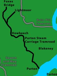
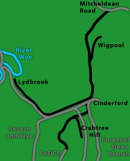
|
DFMU&PR in black, surviving railways
in grey, rivers blue, land green.
|
The next scheme of note to
propose running up the valley from Awre was the Dean Forest,
Monmouth, Usk and Pontypool Railway - a lengthy, good quality
cross-country route which was placed before Parliament in 1845
and promptly rejected. Its aim was to carry iron (and, to a lesser
extent, coal) from the Forest to the ironworks at Merthyr Tydfil;
other railways would complete the route west of Pontypool. It
avoided all the tricky coastal bits of South Wales Railway (past
Purton and below Chepstow); they were replaced by a tunnel at
Howbeech, lengthy banks up to Coleford and a few nasty bends
(none of which really concerned promoters armed with reasonably
powerful 50mph locomotives). Unfortunately, like its predecessors,
it also involved competing with the Severn and Wye. |
After a pause the western
half returned as the Coleford, Monmouth, Usk and Pontypool Railway,
which shut up the Severn and Wye and allowed the plan to proceed;
the easy bit of the route, between Monmouth and Pontypool, was
completed in 1857. The Coleford extension was completed to a
rather lower quality by the GWR in 1883, while the Severn and
Wye upgraded their tramway to provide a similarly tortuous route
to Coleford from the Severn and Wye mainline at Parkend. Beyond
Parkend, the 1845 scheme proposed a tunnel to pass under a hill
to Howbeech, from where the mainline was to continue to Awre,
with a branch from Howbeech to Foxes Bridge.
In due course some local
businessmen realised that this valley was not going to get a
link provided by outsiders any time soon, so they adopted the
section of the scheme which proposed to link Awre with Foxes
Bridge and made it the fourth and last railway company to open
shop in the Forest. Early financial problems delayed construction,
led to the contractor being paid in worthless bits of pink paper
which the railway described as its shares and prompted a decision
to leave the last 1½ miles up to Foxes Bridge for completion
later. Linking Awre Junction with New Fancy Colliery via Blakeney,
the new railway was completed at the same time as the Severn
and Wye Railway was converted from a tramroad into a proper railway
and began to gain from the increase in profits. Its decision
to build a new mineral loop, creating a lasso around the centre
of the forest, had much the same effect as a lasso when it opened
in 1872, pulling all traffic from collieries such as New Fancy
towards its port and junction in Lydney. Alas, the new railway
never stood a chance. Its pleas to the mighty Great Western Railway
to buy or bail it out largely fell on deaf (and broke) ears;
by the late 1870s it couldn't afford to print its own accounts
and the Great Western was working it on the basis that it was
there, so they might as well and might eventually get some money
back sometime.
The Central line was eventually
absorbed by the Great Western at the Grouping in 1923, demonstrating
that several railways which remained independent until then did
so because the phrase "damaged goods" was an understatement.
By then the Great Western was taking over a line with two miles
of operational railway plus a further two miles which pointed,
devoid of traffic, into a particularly isolated part of the Forest.
Those shareholders who wrote to the GWR after reading an article
in the Daily Express about a railway with no owner, enquiring
about the possibility that they might get paid something, were
told that they should contact the Directors and Officers of the
Railway who, the GWR kindly explained, had all resigned some
years previously (when it became apparent that the railway couldn't
afford to pay them). On Grouping Day the 54-year-old railway,
which had been the beneficiary of some £141,000 and had
generated a grand total of £32,000 over the years, passed
to the GWR free, gratis and for nothing in lieu of monies
owed to its new owner. (The Bank of England makes that £12.5million
in and £2.7million out; about £50,000 per annum in
earnings in modern money.) Its sorry remnants, worked with the
aid of a red flag, were treated rather well for a broken freebie
and survived until 1949.
The Severn and Wye Railway
stands amongst a very small selection of lines which successfully
killed a competitor and the grandly named Forest of Dean Central
Railway stands as one of an even smaller selection of routes
which obediently laid down and died. The rural nature of the
area, with minimal need to go to all the trouble of obliterating
railway structures to provide room for development, means that
the entire route can be followed even now, as seen in the pictures
below.
|
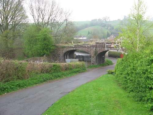
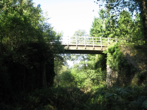
Awre Junction
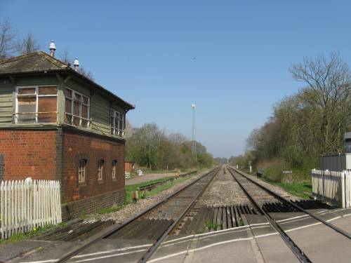
|
Looking north-east towards
Gloucester, this April 2010 view of Awre Junction signal box
and the mainline shows just how much the place has declined -
or how little, given that it was never very busy. The station
was built for the new line and had platforms on the mainlines
with a couple of sidings and loops for shunting branch trains.
The branch never carried passenger trains and even at its peak
between 1868 and 1872 traffic seems to have run only on alternate
days. Most of the sidings were located on the derelict land beyond
the signal box with connections to the mainline at each end.
The station and the actual divergence of the trackbeds were behind
the camera.
The junction remained essentially
the same throughout the railway's career, carefully laid out
with no facing points on the mainline so trains from both directions
had to reverse onto the branch (which helped everyone get used
to the idea of going backwards, since there was no loop at Blakeney
and so from 1921 all trains had to be pushed up the branch).
With the closure of both station and branch in August 1959, the
site was cleared of all except the essential 1909-built signal
box, required to control the level crossing. In due course, like
the rail traffic, the signalling requirements shifted to Lydney
and the box has stood derelict next to the former mainline since
the 1970s.
Due to the Great Western
influence on this area, the South Wales Railway was constructed
to the Great Western's very own track gauge of 7'¼".
The Forest of Dean Central was also built to this gauge and the
main Forest of Dean Railway was converted to it shortly after
being acquired by the Great Western. When the Severn and Wye
was rebuilt it was also persuaded to lay its track to this gauge.
However, standardisation with the rest of the network in 1872
saw these lines all relaid to the normal 4'8½", leaving
a legacy of over-wide infrastructure and excess width between
the running lines on double track. |
|
Blakeney station
|
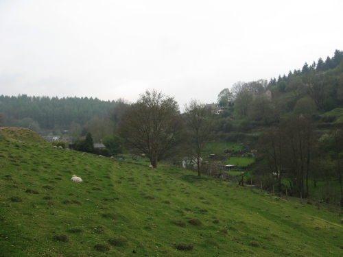
The line then runs attractively
up the comparatively wide and open valley to Blakeney, which
was the most important intermediate station on the branch. This
record was primarily achieved by being the only intermediate
station on the branch (the other points of note were mostly just
sidings) since Blakeney was not what might be called impressive.
As the line was goods-only, things like platforms where unnecessary;
since it was only an intermediate stop on a line which was only
used by one train per day (three days per week) it had no need
for a loop. Thus the trackwork consisted of the main line from
Awre to Howbeech, New Fancy and Foxes Bridge (which ran north
along the embankment to the right) and a single siding with crane
and loading platform (which ran behind the stone building and
connected at the Awre, or far, end of the site).
When the line's fortunes
went downhill this little site became its northern terminus.
In the continuing absence of a loop - the line's long term future
was evidently deemed to be bleak even in the 1920s - the locomotive
ran around its train at Awre and then propelled it to here. The
guards van - generally of the "Toad" variety - would
be deposited on the mainline and the wagons pushed into the siding.
Various local lorries collected the goods brought up on the train
and provided some for the return journey, for which the locomotive
would be at the front. The end of the line was denoted by a sleeper
tied across the rails on the embankment to the right, which is
tradition for doomed lines which aren't likely to be terminating
there for much longer.
A maximum speed of 10mph
was imposed over the line, probably because this was the maximum
for the ascending trains and so only half of the services using
the route could go faster in any case. The guard provided warnings
to the driver from his van at the front of the train with the
aid of a red flag and a horn. After the line fell into disuse
it remained in the Western Region's Working Timetable for some
years with empty columns and no booked trains. The track was
removed in early 1959. The stone building in the centre, now
partially hidden behind a tree and seen here looking towards
Awre in April 2010, is original. |
|
Blakeney Viaduct
|
The village was also home
to the railway's two main engineering features - a pair of short
viaducts with the line's characteristic low arches, rather reminiscent
of Brunel's viaduct at Maidenhead. None of the underbridges along
the route left all that much headroom, averaging at about 10ft,
and consequently only one survives intact. This is the upper
one of the Blakeney pair, crossing a local road, the scenic route
to Parkend and Coleford, several drives and the local stream.
Although the arched sections are intact, the two girder spans
over the scenic route and the stream were demolished - along
with all of the smaller viaduct, which crossed the A48 Lydney
- Gloucester road - in April and May 1959.
The viaduct had not actually
been seriously used since a 1921 strike prompted the abandonment
of Howbeech Colliery and killed the Blakeney to Howbeech leg
of the line. Officially closed in 1932, the track was lifted
in 1940, leaving a stub of slightly less than two miles for the
occasional freight train. Until then trains could work to Howbeech
after a check of the decaying structures to ensure that they
would survive the experience.
Blakeney might have survived
longer had someone bitten the bullet and provided a passenger
service over the stub of the line. A stopping service from Gloucester
to Blakeney might not have survived Beeching but would have left
the Great Western with something more approaching a legacy for
their own line into the Forest. Instead, the last goods train
from the well-placed goods yard ran on Friday 29th July 1949
and Blakeney has not seen a train since. |
|
North of Blakeney
|
Once over the second viaduct
the railway passes through a short cutting and then heads up
the valley on a hillside ledge. The valley is obediently straight
for about quarter of a mile before it twists left and then sharply
right. The railway solves this problem by sweeping across the
valley and plunging through the hillside in the centre in a deep
cutting. With the closure of the line, the cutting has been filled
with rubble and is now impossible to spot at its northern end.
At the southern end, however, it can be distinguished as the
road passes over a deep ravine which is soon blocked by rubble.
The deep cuttings are one
of the few things which marks this line out from the other railways
in the Dean, which were all built along the routes of earlier
tramways and so opted for fairly minimal earthworks, instead
utilising steep gradients and sharp bends. This new railway,
which does not use a former tramroad as a basis, went for more
sweeping curves, high embankments and deep cuttings, although
it still ended up with the steep gradients. The Severn and Wye,
Forest of Dean Railway and Coleford Branch all opted for tunnels
whenever they encountered a hill which they could not easily
go around and the Severn and Wye built an impressive viaduct
across the valley at Lydbrook. The impressive viaducts on this
line were rather low and not exceptionally long; where the line
has to cross over the valley in the distance it uses a high embankment.
There were no tunnels anywhere along its 6-mile route. |
|
Blackpool Bridge
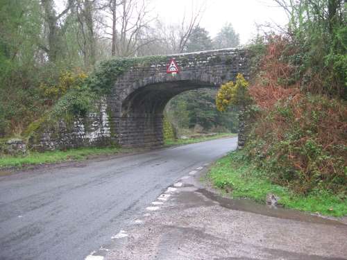
|
Two obstructed cuttings
and a Forestry Commission-built car park at Wenchford later,
the railway crosses its Blackpool Bridge. The Blackpool Brook,
winding down from Mallard's Pike, passes under the railway with
a culvert which would put some of the Wye Valley Railway's to
shame. The railway then crosses the ancient road from Soudley,
which had a station on the Forest of Dean Railway. While the
low arch - the only complete bridge left on the railway - may
be regarded as a bit of an obstruction, it does prevent large
vehicles from using this road and at least no longer has a gate
under it (one was around in the 1940s, although that may have
been the result of Home Guard exuberance). Built with a headroom
for which most companies would have opted for a girder construction,
the bridge does its best to suggest that the railway that it
carried between 1868 and 1921 (about a third of its life to date)
is still active. The only thing it lacks is the Railtrack sign
warning you that if you hit this bridge the safety of trains
may be at stake (a sign which has been affixed to a number of
other disused railway bridges) - oh, and an actual railway.
North of here the railway
ran up a narrow valley shared with the brook and the road to
Parkend. A girder bridge carried it across the road to Parkend
with the obligatory minimal clearance, with the result that the
bridge is no longer there. The line then wound along the hillside
into the Howbeech area, which had quarries, a colliery and some
rather nice lengths of stone-lined channel for the Blackpool
Brook. At the time of visiting (September 2009) this channel
was bone dry, although that may be a seasonal thing. This picture,
plus the previous pair, were taken in April 2009. |
|
Howbeech Colliery
|
Howbeech Colliery was the
uppermost of a string of industries in a mile-long belt up the
Blackpool Brook valley. With fairly reliable streams to provide
power and a railway which initially wanted to go places and which
subsequently would almost pay you to provide it with traffic
this was a good area to start your heavy industry. Although initially
this just provided some additional traffic to supplement what
little was being produced by New Fancy, from 1872 the colliery
and quarries found themselves as the major source of traffic
for the line.
The quarries slowly slipped
out over the years - most of them had been quarrying back cutting
walls, inferring very light traffic since explosions are normally
discouraged around active railway lines for fear of hitting trains
or obstructing the running line, so scheduling them tends to
be very difficult. The colliery initially featured a shaft below
where the photograph was taken from, with the road across the
centre running around the outside of the boundary and the railway
just beyond that. The rail link to the colliery ran across the
road where the people carrier is parked today. A second shaft
was sunk behind the brambles and bracken to the right in later
years, boosting coal traffic a little. This traffic was dutifully
supplied for around 50 years until a miners' strike killed the
colliery in 1921, taking the railway north of Blakeney with it.
Howbeech Colliery is not
as dead as the railway, however; a drift mine has now been dug
below the trackbed towards the older workings. A two-foot gauge
line allows mine trucks to be worked around the site. Produce
is presumably removed by lorry. |
|
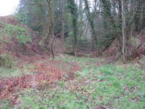
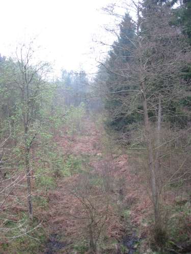
West of Howbeech
|
Beyond Howbeech, the line
had only the briefest of careers. New Fancy colliery was the
only development to benefit from the final mile of track, and
then only for four years. Like many cuttings along the route,
this one is now waterlogged, overgrown and partially filled in.
Abandoned even before the final cycle of railways began to open,
trains ran out of this end of the cutting, past Mallard's Pike
lake and on through the Forest to what had to pass for the terminus.
Under the original proposals for the DFMUPR, this photograph
would have been taken from the middle of Howbeech Junction, where
what was built as the Forest of Dean Central brached off from
the mainline onwards towards Parkend, Coleford, Monmouth and
Wales.
This impressive cutting
is typical of those built for the line - long, deep, slashing
through an arm of the hill and in a location where the other
Dean railways would have gone around the outside or built a tunnel.
The line was clearly intended to last and expensive earthworks
were constructed accordingly. The Severn and Wye's general policy
of doing things on the cheap won out, however, and this route
never even came close to repaying its construction costs. A bridge
part-way along this cutting has been demolished and replaced
by infill, but a rather impressive culvert (5ft 6in high, about
7ft across and with a nice stone floor) remains at the other
end, carrying the Blackpool Brook under the railway. Most of
the brook's time around Howbeech Colliery is spent underground. |
|
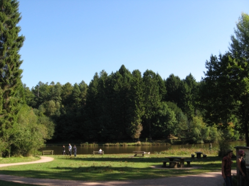
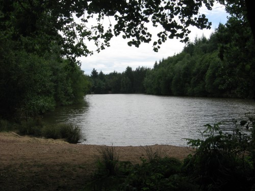
Mallard's Pike
|
If one is to turn around
from the location from which the picture above was taken and
push through a bank of trees, another, drier and more walkable
cutting opens up, which carries the line through a hillock adjacent
to Mallard's Pike lake and opens out to point across the car
park at the trackbed north. Were the line still open, it would
now be a minor tourist route - Mallard's Pike is one of the many
beauty spots in the Forest (when it isn't raining) with a new
"Go Ape!" climbing place and one end of the Forestry
Commission's cycle network. Yet this stretch of the line officially
closed in 1878, having never seen a passenger train (or indeed
the lake, which if the official survey of the line is anything
to go by post-dates closure); the only vehicular access is now
by car or bicycle. Unlike many stretches of track around the
country, it is hard to envisage a scenario for this line which
would ensure that it was still operating today.
Mallard's Pike claims that,
while both mallards and pike are common in the lake, it is in
fact named after Mr. Maller and his turnpike road from Blakeney
to Coleford. Turnpikes were good quality roads maintained by
charging users a toll for travelling along them and arrived in
the 1750s along with the canals and the railways. Initially holding
a monopoly on passenger transport, the highly-profitable turnpike
network was taken by surprise when the railways realised that
they could make some money out of fast passenger trains - and
did so. The network was virtually extinct by 1850 although tolls
continued to be charged on the Cobb into Porthmadog in North
Wales until 2003, when the 10p toll was abolished, taking the
associated three-mile tailback into the history books with it.
Modern toll roads include several major road bridges and the
M6 (Toll) which, despite offering savings of millions of pounds
a year by allowing people to dodge the traffic jams in central
Birmingham, is used by virtually no-one. |
|
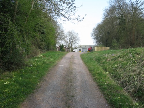
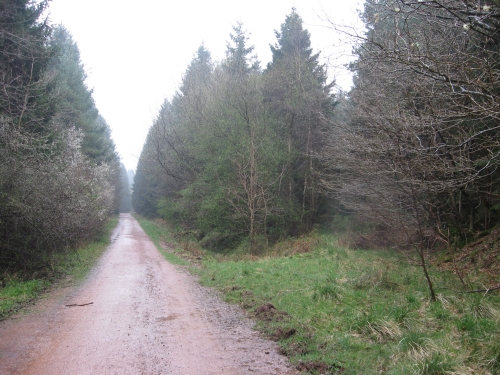
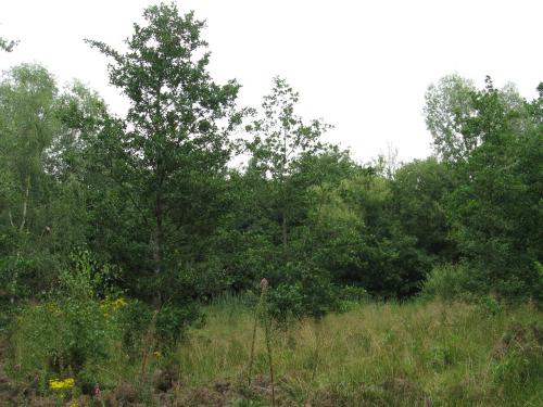
New Fancy Junction
|
Clambering north from Mallard's
Pike, the line featured its final overbridge over a little Forest
track, but this has now been demolished, the track straightened
and the approach embankments removed. Shortly after we come to
one of those little idiosyncrasies of the Forest's rail network
- the junction which points in the wrong direction, imposed by
the gradient from Mallard's Pike and the following gradient to
New Fancy. Trains from Awre arrived on the left-hand path (then
a single track railway) and entered the loop/ pair of sidings
behind the camera. The train then headed off between the trees
along the grassy belt on the right towards New Fancy colliery.
Upon their return they simply reversed the process.
This method of working naturally
introduced a delay and so, when the Severn and Wye came along,
their sweet talking and the offer of access to Lydney Docks seem
to have persuaded the colliery management to change haulier.
The Severn and Wye Mineral Loop crossed the New Fancy branch
on the level, but this seems to have raised few concerns. Arguably
the Severn and Wye's methods for working two trains on the unsignalled
Mineral Loop (cross fingers and blame the signalman for the inevitable
accident) were far more worrying than a minor flat crossing anyway.
This was the quietest of
the extremities of the Forest's railways, with no proper roads
in the vicinity and the nearest house being located well over
a mile away. |
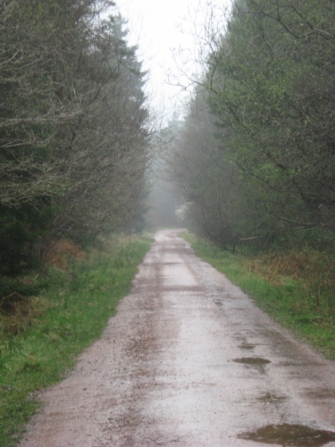 |
Looking north from the same
spot, we see the location of the turning sidings. About 300 yards
further up the line it crossed one of the many Forest tracks,
which is still there today. Barely 50 yards beyond that the Foresty
Commission's new road takes a sharp turn to the right, abandoning
the trackbed which has brought it from Mallard's Pike. The turn
marks the most northerly extent of the intrusion of this Great
Western-supported line into the Forest; what extends beyond is
a deserted and unused strip of land prepared for rail use but
never turned into a railway.
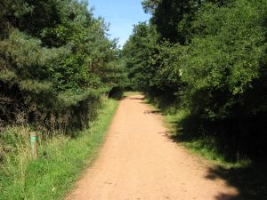
The Forest tracks, some
of which have names, are mostly run along very old roads which
linked mines, houses and general sections of woodland. This one
is unusual in being laid on a railway - the Forest of Dean Railway
is mostly derelict or footpaths and the Severn and Wye network
has almost entirely been converted into cycleway, except for
the bits which the Dean Forest Railway has re-opened. Although
the Forest is mostly open access this does not mean that the
tracks are actually public roads, being intended purely as bridleways
and a means for Forest staff and those who are lucky enough to
live at the end of one to get around. As footpaths go they are
very good, offering a solid surface which rarely vanishes into
a bramble bush or a bog, although one or two of those marked
on the current OS Explorer Map of the area (OL14) no longer exist
so a compass is still recommended. As cycleways they tend to
be rather sore on the bottom due to the uneven surface made of
medium-sized stones. As railways they are entirely useless; taking
a train along one tends to rapidly lead to a serious accident. |
|
Central Bridge
|
In a most unusual move,
the Severn and Wye actually co-operated when its new mainline
was obliged to cross the authorised, if incomplete, Forest of
Dean Central Railway. It built three bridges in one embankment
- one over a still-unsurfaced Forest road, one over this railway
and one over the Blackpool Brook (which came off worst, with
an 8-inch high culvert). Unusual in that it rendered unnecessary
the railway that it crossed, this structure provided neither
company with any particular benefit and when British Rail lifted
the track on the Severn and Wye Mineral Loop in the 1950s it
took the bridge span with it.
The replacement structure,
made entirely of timber resting on the original abutments, was
built when the Forestry Commission turned most of the abandoned
stretches of the Severn and Wye network into cyclepaths. While
the line into Cinderford and the bottom end of the Mineral Loop
remain abandoned (the former has too many tracks slashing through
the trackbed and the latter passes through a collapsing tunnel),
the new transport network has attracted traffic levels far beyond
those obtained by the Severn and Wye Railway. Always known as
"Central Bridge", this span has even been marked as
such on the cycleway leaflets - though few will realise the insignificance
of what lies beneath the timber girder. |
 |
And so the railway ended.
Looking north from the Severn and Wye's overbridge, we see what
work took place to extend the railway deeper into the forest
before the scheme was abandoned, heading up the valley towards
Speech House lake. Strangled by its smaller competitor, the Great
Western never ran a revenue earning train under this bridge.
The trackbed which was deemed by the Official Survey to have
been prepared for use ends at Ash Ride, which is marked by the
line of trees across the trackbed in the distance.
This is not the end of the
trackbed, although it is beyond the end of the track, so does
not constitute the end of the article. As this spot featured
one freight-only line crossing another freight-only line, there
isn't even the option of returning to civilisation in a railway
carriage, which means that you may as well stay on for the last
bit. There is a sort of nice feeling about exploring this last
stretch of the Forest of Dean Central line because you know that
you're seeing as much as anyone ever has seen; nobody was born
too late to travel on the "last ever" railtour out
here. (Equally it's a rather sad feeling that people went to
a lot of effort, spent a lot of money and got nothing for it.)
It is hard to take pictures of the line north of here, as it
is mostly overgrown with trees and is rather indistinct anyway.
In some respects, this means that it is the most fascinating
bit to explore. Other people may wish to stick with the bit south
of Mallard's Pike. Whatever your view, the only way to get back
to Awre from Central Bridge is - and always has been - to walk.
Sorry.
For the last mile the trackbed
consists of a flattened surface running through the trees (rather
literally, as a lot of them grow on it), visible only if you
really know what you're looking for. The last level crossing,
over Ash Ride and next to a small structure called "Reform
Bridge" (which carries a Forest track over Blackpool Brook),
is followed by a steadily widening flattened surface with the
brook to the left of ascending trains (not that there were any)
and a small bank to the right. This then crosses over a very
small culvert; the next stream north is obliged to cross the
trackbed on the level, and a few yards beyond that the level
surface apruptly ends in a two-foot-high bank. The slightly higher
land beyond has a more crumpled, natural feel to it for another
couple of dozen yards before it rises into the dam of Speech
House Lake (which post-dates the proposed route). |
|
Speech House Lake
|
The Forest's railways crop
up occasionally in various television programmes, but the Forest
of Dean Central probably scored highest when it appeared in BBC
One's show Merlin, which may perhaps make up for the fact
that not a frame of footage appears to have been taken of the
railway while it was alive. You wouldn't have noticed it, although
bits of the filming took place on the proposed route of the trackbed,
which ran through the current site of Speech House Lake. The
lake initially appeared to have been cast as Lake Avalon, in which role it made
some convincing and well-performed appearances across the five
series (although arguably the role would have been better filled
by the larger Woorgreens Lake, just beyond the top end of the
railway, which has reeds, a more obvious island and a rather
entertaining backstory). Unfortunately it did not get to reprise its
role in the grand finale; another larger expanse of water did the
honours. The visible line of the railway ends
less inspiringly in a birch wood below the dam at the bottom
end.
There were two more level
crossings planned in close proximity for Forest tracks; the first
over the path now running along the lake's northern shore just
in front of the camera and the second over Spruce Ride, just
behind the camera. A further level crossing would have been required
about quarter of a mile further on. A few traces exist north
of the lake, heading up towards Foxes Bridge Colliery, making
it just possible to follow the former trackbed for the rest of
the way. There is a dry ditch running north from Spruce Ride
here which you keep to your right; eventually a second appears
on the left about ten feet from the first and this should be
kept to the left for the rest of the way, ignoring the first
one, which will eventually vanish. Two paths are crossed en
route; the first a dozen yards west of a sharp left bend
between two tall pine trees and the second at about the same
point as the accompanying stream. Eventually what was to be the
trackbed will apruptly burst back into the open; the ditch should
still be kept to your right as you battle the bracken. An embankment
which probably dates back to Purton Steam Carriage Road days
crosses the bog; the railway would then have passed under the
road and run a few yards through the trees to its northern terminus. |
|
Foxes Bridge
|
Unfortunately Foxes Bridge
was denied the opportunity to be served by all three of the Forest's
major rail networks; only the Severn and Wye and the Forest of
Dean lines were connected to that particular hole in the ground.
It had a beginning not unlike the Forest of Dean Central, going
to a great deal of expense and still not getting what it wanted.
Initial diggings at a site convenient for the Speech House ended
up producing only water, which is available in vast quantities
all over the Forest at no immediate expense to anyone and so
was of no use to the colliery owners.
The colliery therefore decided
to solve the problem by upping sticks and moving lock, stock
and barrel to Crabtree Hill, three-quarters of a mile to the
north of Speech House. Here they were able to benefit from the
much closer proximity of the Severn and Wye Mineral Loop and
the Forest of Dean Branch, both of which provided spurs to the
colliery. The Forest of Dean Central, meanwhile, found that it
had ended up in the paradox of the runner and the tortoise -
it was racing up the Forest towards the colliery, which in turn
was slowly moving away from the proposed northern terminus -
and decided that it couldn't afford the extension north of New
Fancy. It might have completed its trackbed later, but events
overtook it and the runner had to retire to Blakeney.
Meanwhile the tortoise went
the way of most of the Forest's collieries and its only claim
to fame now is that it marks the highest point on the main circle
of the Forestry Commission's cycle network, which deviates off
the Mineral Loop specially. A large isolated overgrown pond,
north of the Coleford to Ruspidge road and near the rather larger
Woorgreens Lake, now marks the top of Blackpool Brook, the northern
end of the line and the original colliery site. If you're lucky,
you may be able to get back to Awre from here without having
to walk the entire 6¾ mile route again. |
|
An extension was proposed in
the 1850s, when the line was still on the drawing board, to continue
to serve further collieries in the Forest. The Forest of Dean
Central, Lydbrook and Hereford, Ross & Gloucester Junction
Railways - perhaps the longest railway name ever proposed - was
not actually presented to Parliament and so the five-line network,
centred on Cinderford with lines to Foxes Bridge, Lydbrook and
the Hereford, Ross & Gloucester Railway, accompanied by three
branches of varying lengths, was never built as planned. The
Forest of Dean Railway's unopened northern extension settled
the Cinderford to Hereford, Ross & Gloucester bit, while
the Severn and Wye linked Cinderford with Lydbrook. The Forest
of Dean Central never reached Foxes Bridge and there was nothing
much to look at there, so that spur around Crabtree Hill was
unnecessary and remained unbuilt. Perhaps the proposed network's
most notable point was the mile-long Wigpool branch, to diverge
from the mainline a mile or so north of Cinderford at the town
of Drybrook, which planned to ascend out of the valley on a gradient
of 1-in-17.88. At 5.6%, had this rapidly rising spur been built
as a road it would have justified a warning sign; unfortunately
the Hopton Incline on the Cromford and High Peak Railway in Derbyshire
was steeper, at 1-in-14, so it wouldn't have become the steepest
length of railway worked by locomotives in Britain. |
|
There was also an effort
to connect the line up to the Severn Railway Bridge and the Forest
of Dean Branch by means of two short chords, both of which suffer
from straight line syndrome - an interesting condition whereby
some speculators decide that a route between point x and
point y would be useful and amuse themselves drawing a
series of straight lines over the gaps between existing railways.
The idea was that it would be possible to get Bristol from Bristol
to Hereford and thence to Northern England by a somewhat convoluted
route. You head north out of Bristol, cross the Severn Railway
Bridge, join the Forest of Dean Central just north of Awre and
follow it up to Blackpool Bridge before striking north across
country to pick up the Forest of Dean Branch by Blue Rock Tunnel,
a mile or so south of Cinderford. The Forest of Dean Branch can
then be followed to pick up the Hereford, Ross and Gloucester
Railway at Mitcheldean Road; another chord there allows through
running to Hereford. If necessary your train can then proceed
via various extremely minor lines through Central Wales. The
idea was presumably to compete with the dominant and somewhat
quicker Midland Railway. The Severn Tunnel killed the grand schemes
of this sort in this area by providing the option of using decent
double-track railways to get from Bristol to Hereford via South
Wales.
It is perhaps more interesting
to hypothesise as to what would have happened had the line been
built in the 1840s. The basic route would have been very much
the same, but if the Coleford, Monmouth, Usk and Pontypool Railway's
earthworks are anything to go by then the line would have been
set out for double track. Possibly the second line would even
have been laid. A passenger service would have been provided,
although it is unlikely that it would still be operating today.
The 1960s Beeching cuts essentially re-orientated railways in
this area to centre on hubs at Cardiff and Bristol with connections
to various provincial towns and cities in the area; this route
would have been deemed to have been in the business of linking
Cardiff with Gloucester and since there was another line which
fulfilled that function - the South Wales Railway via Chepstow
- this route would have been shut anyway unless Usk, Monmouth,
Coleford, Parkend and Blakeney provided a very good case for
its survival. As none of these places feature in the Beeching
Report, since they had already been stripped of their passenger
services, there is no particular reason to believe that this
well-aligned, if occasionally steeply-graded, route would have
survived to present tourists with its scenic attractions today.
However, the route which
became the Forest of Dean Central would probably have been more
successful and could have dented the fortunes of the Severn and
Wye (which would certainly have never run trains to Coleford).
Unfortunately the reality is that none of the Forest's railways
were well up in the success ratings and there is little reason
to assume that this abortive scheme would have been an exception
- unless it managed to market itself as the eastern end of a
railway between Swansea and Gloucester avoiding Cardiff and Newport,
which might have made it some money.
|
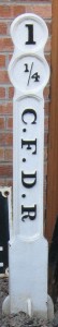
But we will never know and
instead the railway's history has a certain tragi-comic air.
Aside from the remains of the route pictured above, the only
other surviving bit of the Railway is Milepost 1¼, which
Dean Forest Railway has on display at Norchard - and very nice
it looks, although a slight error by the company who cast the
unusual mileposts means that the railway was recorded on all
of them as the "Central Forest of Dean Railway".
It would not be beyond the
will of people to re-open this route - it would merely be a question
as to whether anyone has the will to do so. Given the fact that
the northern terminus would be in the middle of a deep forest
well away from population centres, it is likely that the required
will is absent. About the only use for it would be if the Dean
Forest Railway's expansionists decided to set up a new line linking
Blakeney with Mallard's Pike and Speech House Lake. This would
be hard put to be as unsuccessful as the original line, although
running trains over a stretch of previously-unused trackbed probably
doesn't quite constitute preservation. Foxes Bridge would make
a nice northern terminus if someone really fancies twisting the
line enough to get it up the east side of the lake (the south-east
side of the lake is above the surrounding land already so it
should be possible to scrape the railway around it and run the
first ever train along the trackbed beyond). Unusually, this
is a line where reopening it to broad gauge would probably more
historically accurate than re-opening it to standard - at least
over the top two miles.
Remarkably there appear
to be virtually no immovable obstructions apart from an industrial
base at Blakeney which could probably be shifted if spoken to
particularly nicely with the help of a chequebook. The bridges
are all rather low (and so would all need reinstating), which
might result in some opposition - particularly with regards to
that over the A48 - but are so low that most of the big lorries
which might want to bash them would be persuaded not to by the
fact that the bridge would be coming straight through their windscreen.
If you want to ask why it
should be re-opened, go and sit in the barbecue area at Wenchford
on a balmy evening. Imagine a pannier tank with three coaches
clanking into a wayside halt built on the current car park. That's
why. |
Forest of Dean
Central Railway
Awre Junction to
Foxes Bridge Colliery: Incomplete
Awre Junction to
New Fancy Colliery: 1868-1872
Awre Junction to
Howbeach Colliery: 1868-1921
Awre Junction to
Blakeney: 1868-1949
|
The background image for
this page shows the Forest of Dean Central looking north from
its level crossing over the sidings at New Fancy towards the
ultimate terminus of the line. The bufferstops were located just
where the path turns away and the trackbed beyond there to Foxes
Bridge remains unused.
Isolated and quiet, the
northern terminus of the line contrasts starkly with the Cinderford
terminus of the Severn and Wye and Forest of Dean railways. On
a bright sunny day, like the one shown in August 2009, it is
a pleasant spot to linger a while on this now rural line. |
Unlike other railways featured
on this website, this railway tends to feature only in books,
magazines and folios of which it is not the main point of interest.
Aside from this webpage, there is an article by noted Forest
railway historian Ian Pope in Railway
Archive No. 12, a short bit in Middleton Press's Branch
Lines around Ross-on-Wye by Vic Mitchell and Keith Smith (don't
ask what it has to do with the network around Ross) and a few
pages in Forest of Dean Railways - Layouts and Illustrations.
This latter describes its history as "probably unique in
railway history" and so far we have been unable to think
of any examples to contradict this. H.W. Paar devotes two chapters
to the line in The Great Western Railway in Dean - A History
of the Railways of the Forest of Dean: Part Two (first edition
1965, second edition 1971). Only Paar and Pope manage pictures
of the portion of the line beyond Blakeney; Pope has more pictures
and maps, but Paar has a gradient profile and a decent bit on
the proposed tramroad. The Public Record Office holds the Official
Survey of the line under RAIL 274/84; it shares the volume with
the Forest of Dean branch from Newnham to Mitcheldean Road, which
was also never opened over its entire length (despite being completed).
The fact that the two surveys are bound together at least means
that you can't get them confused and order the wrong line. They
also have the "Absorbtion Papers" (Rail 258/229) which
consist of four large bundles of interesting sheets of paper
discussing the line's atrocious career. The various aborted schemes
can be found at the Gloucestershire Records Office.
__________
<<<Wye
Valley Railway<<<
>>>The
Main Line>>>
>>>Coleford,
Monmouth, Usk and Pontypool Railway>>>
>>>Coleford
Branch>>>
<<<Railways
Department<<< |