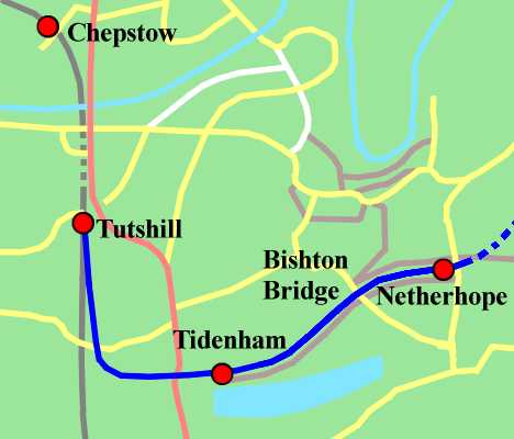
Part 1: Wye Valley Jcn to Netherhope
(calling at Tidenham)

|
Part 1: Wye Valley Jcn to Netherhope (calling at Tidenham) |
|
|
|
Map not to scale.WVR in dark blue. Stations marked by red dots; only Chepstow is currently open. Footpaths in brown (proposed and in place). Local roads in yellow. Major roads in red. Water in pale blue. North at right. The first section of the line remains in situ, with the exceptions of the junction and most of the trackwork within Tidenham station. Although unsuited for regular use, this track will be useful as a starting point from which to work on the rest of the line. Once work elsewhere is completed the focus will shift back to restoring this area. NOTE: Several pictures along this section were taken from private property without asking. This was on the grounds that if asked the owner would, sensibly, refuse permission to amble round. You are advised not to imitate our despicable behaviour. |
|
Tutshill Halt 
|
Tutshill Halt opened in 1931; the site is seen here from the adjacent overbridge looking towards Chepstow in 2008. It was a simple timber affair, with a platform on each side of the main line. The platforms were accessed by means of steep timber flights of steps. The halt was served exclusively by Wye Valley trains and accordingly closed with the branch, although its location on the eastern outskirts of Chepstow should really (had it been properly served) seen it cling on for at least another four years. Reinstatement for the new WVR is a fairly simple thing to suggest. The junction is on the other side of the bridge, behind the camera, and only connects into the right-hand (Gloucester bound) line. The crossover to the left-hand (Newport-bound) line is half a mile away at Chepstow station. All WVR trains would therefore be on the right-hand line at this point. Accordingly, the necessary 75m platform could easily be accomodated between the junction and the tunnel in the distance (added in 1987 for the benefit of the A48, which is behind the trees to the right.) The slope would provide access. Sustrans suggests installing a path along the top of the cutting wall to the left for their cycleway and an access route across the A48 to connect into this part of Tutshill; these two links would provide access for the local community to the re-instated stop, which would serve Wyedean School and the Tutshill community. Due to the expense of building new stations on Network Rail tracks, it would potentially be cheaper to lay on a limosene service between Tidenham station and Wyedean School for the pupils than it would be to reinstate Tutshill Halt. It is therefore merely a nice-to-have. |
|
|
|
|
Wye Valley Junction Cyffordd Dyffryn Gwy 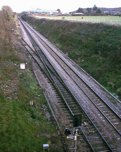
|
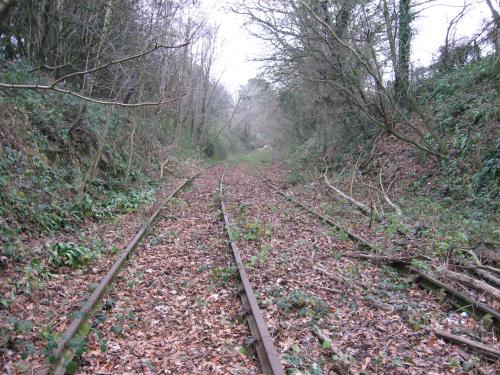
The mainline arrived at Wye Valley Junction in 1851 and this obscure location then spent the next three years as the western terminus of the Great Western mainline from London Paddington. Traffic had to transfer to road vehicles at this location, called Chepstow East, for the awkward journey to pick up the rest of the South Wales Railway to Swansea at Chepstow West. The matter was tidied up when a bridge was built across the Wye by Isambard Kingdom Brunel (or, rather, by a large bunch of strong men employed by Brunel to build an awkward bridge) and Chepstow East duly shut up shop; the suffix "West" was dropped from its cousin and that station (complete with original Gloucester-bound building) remains as Chepstow station today. The Wye Valley Railway was introduced to the mix in 1876. It was a "double-lead" junction; the line descending the bank to the left from Tidenham station split into two, with one track to join each of the main running lines. This provided a short length of double track, occasionally used as a passing loop, at the bottom of the incline. The junction became a single-lead affair after traffic levels were deemed to be too low to warrant the full-blown junction. On this side of the bridge the trackwork looked much as it does in the picture. On the Tutshill side there was a crossover between the Gloucester- and Newport-bound lines. After the line between Tintern Quarry and Monmouth closed the signal box at the junction was also shut and the crossover removed, with that at Chepstow taking over the responsibilities. The junction was provided with a little groundframe for moving the points, seen by the white box at centre left; signal N163 watched over proceedings. Signal N163 remained until the 2012 resignalling of the line, but the pointwork and associated shunt signal were removed in 2007. This 2005 image continues to be used on the grounds that it provides a rough idea as to what the junction will look like if re-instated, except the line won't be so overgrown (since someone will be looking after it), it won't need the groundframe (since it would be controlled properly from Cardiff), there will be a proper "feather" on top of N163 (ditto) and N163 itself will have been replaced by a newer signal operated from the new signal box at Cardiff. (The actual new signal has been helpfully plonked in the middle of the WVR line and will need moving at enormous expense, probably to beyond the junction; the signal for the junction would be better placed at Chepstow station.) |
|
|
|
|
Tidenham station 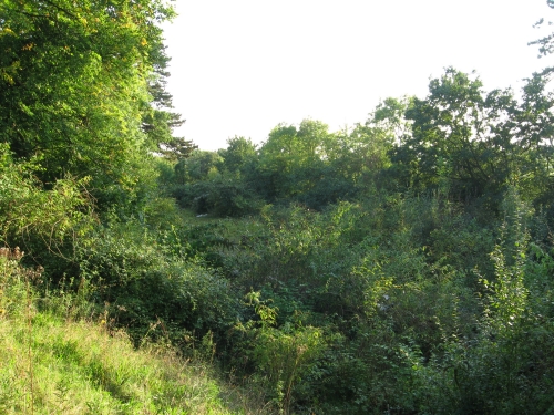
|
Tidenham station (seen here looking down on the site, in a Chepstow-ish direction, from a bank on the station's north-east flank in 2008) was the first stop out from Wye Valley Junction. It was closed in 1917 to free up staff and got demoted to a halt in 1955, but otherwise survived fairly well (with its basic and attractive little building and sylfaen surroundings) until the bulldozers arrived in the late 1960s and squashed the whole place flat. The attractive building was replaced by an unattractive collection of bits of steel, which were used for loading stone into ballast trains. After stone traffic ceased the bulldozers returned and removed the bits of steel, plus most of the trackwork, leaving behind a derelict trailer with some pot plants in it. The pot-plants and the buddleia are now thriving. The station isn't. Re-opening would see the station torn apart again to level out the 1-in-66 gradient through the site. A new building would be installed with a cycletrack running around the outside to head north alongside the railway. This grassy bank would become a viewing platform and picnic area. At the south end of the site an access road descends into the old quarry area to link with the A48; this would be reconditioned and the relevant bit of the old quarry area surfaced to provide a park-and-ride facility. As part of the promotion of the station as Tidenham Parkway, it would be staffed and provided with useful facilities such as a (very) little shop and toilets. The benefit of levelling out the site would be that it could be used by terminating trains - be they frequent shuttles from Cardiff or a high-peak steam service from Tintern. Exact infrastructure requirements would vary based on the service level. The basic hourly through service to Monmouth would require a platform and single running line (and no work on altering the gradient). Adding terminating trains or a through service would require a loop opposite the platform (for stabling terminating trains and running round the steam loco). Adding both would require two platforms and a footbridge. |
|
|
|
|
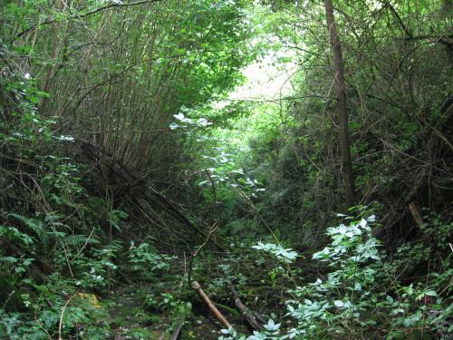
North of Tidenham
|
Pushing through the bushes north of Tidenham station abruptly opens up the results of the early '80s investment in the line - a rather impressive and gracefully curved stretch of double track which represents the only opportunity to see what the WVR's promoters were ultimately envisaging for the line. Unfortunately we're planning to get rid of it. This picture looks south towards Tidenham station. The re-levelling of this stretch would take advantage of the double track cutting to provide a single track line at a slightly lower level without increasing land take or making the cutting walls substantially deeper. The quarter-mile stretch of double line is of little operational use; should room be needed for stabling terminating trains while through services run through Tidenham station then they will have to be parked on the station loop. The remaining running line will be located closer to the alignment of the right-hand track than the left-hand one. The remaining cutting space will be used to provide a footpath/cycleway between Tidenham station, Bishton Bridge and Netherhope Halt alongside the railway. A footpath which currently crosses an adjacent field to meet the railway along this stretch will be linked in somehow. |
|
|
|
|
Bishton Bridge 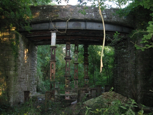
|
Sadly the double-tracking of the line north of Tidenham didn't reach far enough north to take advantage of the original Company's ambition to build a double track secondary route. As part of this they built all three original overbridges for double track. Had the line actually been doubled three single-track overbridges would have been the least of their worries, given that three of the four intermediate stations, both tunnels, both river crossings and all the underbridges would have had to be rebuilt to accommodate the second running line. In the event it wasn't an issue and in 1981 the line under Bishton Bridge, seen here in 2008 looking south, was taken out of use after the bridge had spent some 104 years (it was built a year after the line) spanning a single track. Due to its poor condition it was then shored up with a set of exciting metal supports. Repairing the current structure would be a waste of time (it's over 130 years old and by no means unique - WVR Bridge 1 is identical and similar bridges exist all over the place) so the two simple options are to shore it up with a permanent brick support (Sustrans's preference) or demolish it and build a new bridge (our preference). The brick support will have to be off-centre if a railway is to pass comfortably beneath and it would just store up problems for when the bridge decays a bit more. A new bridge would have a longer shelf-life and avoid the need for awkward central piers. There is no particular reason why the original design could not be reused. |
|
|
|
|
Netherhope Halt
|
Added to the line in 1932, this was the last additional stop to be put into WVR schedules, which then remained the same until closure. It is again seen here looking south in 2008 from underneath the bridge carrying Netherhope Lane, from which the halt derived its name, over the railway. It was a little ash and cinder platform with timber facing and a small corrogated iron shelter. Access to the road was by a short flight of steps (which sort of survive today) and a ramp along the top of the cutting to the left. Nowadays access to the cutting is more easily obtained by the path created by the workers installing the fence across Tidenham Tunnel's south portal (which is 10 yards behind the camera) in 2008. The new platform would be accessed by the same means as the old one, although the path from Tidenham station to Netherhope Lane would provide step-free access at the south end. A more modern shelter would be provided and some effort made to persuade nearby residents that they would like to "adopt" and look after the halt (which would still be a request stop and which we would naturally do major maintenance for - but if they adopt it then there would be better gardens and a tidier air than if we have to pay someone to manage it). It is marginally more convenient for Tidenham than Tidenham station, but parking here is not possible. Therefore Netherhope will be the station for people who want to walk or cycle to a train (forms of transport ideally suited to Netherhope Lane) and Tidenham the one for people who wish to drive (since it faces straight onto the A48 and is otherwise inconvenient). |
|
|
|