| Part 7: Wyesham to Monmouth |
 |
|
|
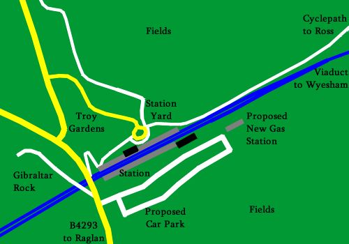
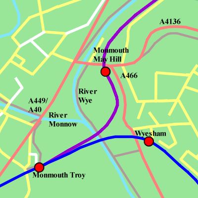
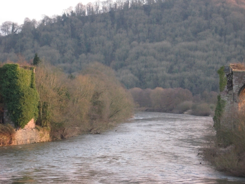
Map not to scale.WVR in dark blue; Ross and Monmouth Railway in purple. Proposed stations marked by red dots, none of which are currently open. Footpaths in brown (proposed and in place). Local roads in yellow. Major roads in red. Water in pale blue. North at top. The final length of the line carries it away from the banks of the Wye and out of the gorge from Chepstow. Skirting around the hillside between farmland and the southern outskirts of Wyesham, it joins the former Coleford branch at Wyesham Junction and then turns west to descend across the Wye on a very fine and steadily decaying viaduct. Once over the Wye and floodplain, it twists into Monmouth Troy station, former junction station for Coleford, Pontypool and Ross-on-Wye. |
|
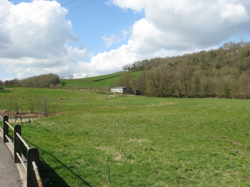
Wyesham
|
Wyesham began its railway career as an interchange wharf between the tramroad from Coleford to Monmouth May Hill and the Coleford, Monmouth, Usk and Pontypool Railway. With the opening of the WVR the tramroad fell into disuse and the spot became unimportant. Plans to make it the south junction for a triangle of lines between here, Troy and May Hill fell through. So the next step came in 1883 when the Coleford Branch opened and Wyesham Junction was created at the south end of the site. The Coleford line closed in 1917 and the junction went with it. A renaissance came in 1931 with the opening of Wyesham Halt, towards the left side of the picture. This was a simple timber trestle platform with corrogated steel shelter. It closed in 1959; the last passenger train to roll past was pelted with snowballs. The replacement station would be a concrete and tarmac platform with a fairly basic shelter (though it might look a bit posher than those elsewhere on the line, since Wyesham serves a reasonable number of people; in such an event the design would roughly imitate the houses). The trackbed has been slightly infringed upon at each end of the site by some back gardens. A few tweaks would be made to the curvature to avoid these back gardens and replacement earthworks provided accordingly. The flat space in the foreground would become a carpark. |
|
|
|
|
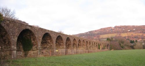
Monmouth Viaduct
|
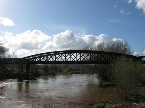
Monmouth Viaduct is, for reasons known to someone, not protected by any form of listing, designation, registration or generally anything other than the protection afforded to buildings which are too dangerous to demolish. It is a rather fine stone structure spanning the Wye and associated floodplain. It was probably at its finest in the first twelve years of its life, when it spanned the river in splendid isolation; in 1874 it was joined by an embankment and second river crossing for the Ross and Monmouth Railway. On the plus side, the Ross and Monmouth bridge is a useful place from which to take pictures of the enormous gap in the structure where a lattice girder once carried the single running line across the river. The benefit of the viaduct not being listed is that refurbishment could take place without worrying about ticking the relevant conservation boxes, though out of a spirit of historical integrity the refurbished structure would still resemble the original. Ivy and trees would be removed and fencing provided along the sides to reduce the risk of trackworkers falling off. Several arches would have to be completely dismanted and rebuilt. As was originally the case, the river would be crossed by a single lattice-girder span. |
|
|
|
|
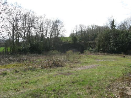
Monmouth Troy
|
Monmouth Troy, seen here from the middle of the site looking west. was a rural bustling country junction of some minor note. Opened in 1857, it ended up with two platforms, a sizeable goods yard and services off four railways. In 1954 three of these railways provided it with a total of 19 passenger and three goods trains daily (Sundays excepted - when there were hardly any trains at all). The last train left in 1964. The buildings have been cast to the four winds (except the main block, which has gone to pastures new), but traces of the platforms and the portal of the tunnel which took the line to Usk and Pontypool under the Gibralter Rock survive. A housing estate occupies the goods yard off to the right and a small gas station squats by the station throat. A playground has also been put into one corner; this will be retained. Re-opening will therefore be an interesting exercise. Task one will be to buy a suitably-sized strip of the field behind the trees to the left. This will be used as a car park and the gas station relocated to the bottom end of it, freeing up the throat. Task two will be to clear out the gap between the platforms and open up the tunnel portal. Two tracks will be relaid. It is unlikely that anything much will be done with the second, further, platform in the short term beyond making it look nice and installing a running-in board with the station name in big letters at the east end. Task three will be the reinstatement of the main station building to provide a ticket office and toilets. The ticket office will be joined by a shop selling tourist stuff, doing basic information, offering a limited selection of food and acting as a corner shop for the locals. Task four will provide an attractive area at the front of the station, connected into the current suburban cul-de-sac. This will be used as a pick-up and drop-off point with a small taxi rank. Residents of the cul-de-sac are asked to balance the increased traffic levels with the benefits of a hourly rail service and the fact that this rather tatty corner of town will look rather attractive once it's all done. Task five will provide an additional path around the back of the houses on the cul-de-sac down to the Monnow crossing. This will reduce the number of foot passengers wanting to pass through the cul-de-sac. The cul-de-sac is having a cyclepath run through it so the necessity of this is debatable, but providing it may count as polite. A ramp will be provided up the hillside adjacent to the tunnel portal for the same purpose and to provide access to the car park. If the lines from Ross, Coleford or Pontypool are ever reinstated (unlikely) the station will be restored to its former glory with two platforms, footbridge, separate restaurant building and signalling. |
|
|
|
|
Ross and Monmouth Railway
|
A fuller article on the Ross and Monmouth Railway is available here (internal link) but, in essence, this was the slightly older sibling of the WVR which was authorised shortly beforehand, opened a couple of years earlier and closed to passengers at the same time. Closure to goods traffic was more drawn out and the southern section of the line - linking the main Monmouth station at Troy with the R&M's theoretically temporary station at May Hill by means of the bridge to the left - spent its last few years as an extension to the WVR. It is now proposed for conversion to a cycleway; since we have on occasion had cause to wish for it to be a cycleway ourselves and the R&M has been too heavily obliterated to bring it back we're not going to waste our breath arguing. Instead, the cycleway will be used as an easy connection between Troy station and the town centre, Troy being a little way out of town. It will also link the railway to the Peregrine Path (see next point) and will eliminate any claims that Troy Gardens (the estate built on Troy goods yard) is a cul-de-sac which will be disturbed by a rail service. In the longer term the cyclepath may be converted back into a railway to provide a more convenient Monmouth terminal. The benefits of this will be balanced against the costs of restoring the bridge, the inconvenience of removing the cycleway and the operational issues associated with turning the train round at Troy for a ¼-mile journey. (About 20 minutes would be required for a 6 minute round trip.) A direct link between Wyesham and May Hill would be preferable. Unfortunately the WVR went bankrupt before it got round to building that side of the triangle and there is now no room to install it. Accordingly if trains are to get closer to Monmouth than Wyesham (which is a very long way from the town centre) they will have to go to Troy station. Even more preferable would be using the proposed Monnow Valley Railway alignment to provide a station at the south end of Monmouth's main street, adjacent to the Gated Bridge and former cattle market. Unfortunately the MVR was never built and the proposed alignment has been thoroughly obliterated. |
|
|
|
|
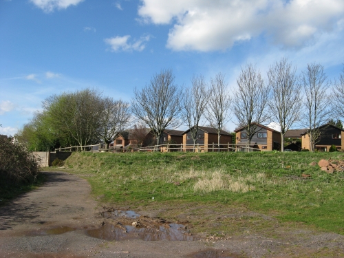
Monmouth May Hill
|
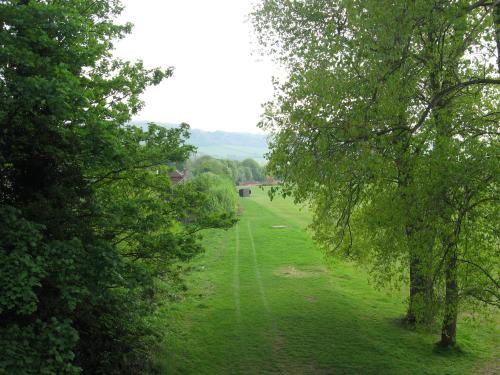
In the event of trains running back across the Wye from Troy station they would terminate on the low embankment seen in the upper picture, at a new station on the south side of the bridge from which this picture was taken, which carrys the A466 over the Ross and Monmouth. The station would be linked directly into the pavement of the adjacent road. It would be a basic 75m platform with a simple shelter. At this end would be a sand drag and bufferstop with enough room beyond that to allow anyone who currently goes under the bridge to keep going under it. Monmouth May Hill itself is not on the agenda for re-instatement. The simple wooden buildings and basic platform were all removed after closure. Unlike Troy, May Hill was actually convenient for Monmouth and so people wanted to do things with the land. Accordingly the site, northern approach and surrounding open space have all been obliterated with some fairly immovable developments, which are seen in the lower picture. The old railway between here and Symonds Yat is now the Peregrine Path cycleway; between the Yat and Lydbrook it's a public footpath (although Symonds Yat tunnel is firmly sealed up). In about 50 years or so this area may be up for redevelopment and reinstating the railway to Ross will then be a possibility. While we wait for that, May Hill will remain firmly buried and the Peregrine Path will be safe from reinstated rail links. Restoring the WVR will have the benefit that it will give the Peregrine Path a rail link. Accordingly access to Symonds Yat without use of a car from Bristol and South Wales will become extremely easy and therefore much more popular. (Whether this would result in more users or fewer cars would remain to be seen.) The railway could quite easily team up with local cycle hire facilities and the Symonds Yat hotels to provide a cycling day out with lunch at the Yat. |
|
|
|
|
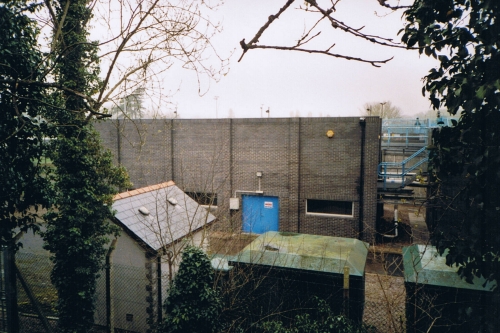
Possible depot
|
A depot at the Monmouth end of the line would be a useful thing if the line were to have its own dedicated train fleet. Otherwise it would be an unnecessary expense. With South Welsh electrification due Cardiff Canton is likely to be familiar with electric traction. Fitting out a depot to look after steam locomotives and their coaching stock would require lots of effort and lots of land. Such facilities would be better off on the spare land adjacent to Chepstow, which is much more convenient for the Tintern to Tidenham leg on which such trains would be used. The west end of Monmouth tunnel is also securely blocked by a Council facility. While the Council might be persuade to move it to show their support, their support will be more easily obtained if no movement is necessary. In the event of a depot being built this nice bit of field, a little to the west of the tunnel, would be the desired site for a basic four-road affair (two tracks in a suitably-equipped shed and two in the open). If no depot is provided Monmouth Tunnel will be opened up to provide overrun and stabling space; it would be quite possible to make the tunnel secure for parking a train overnight while the rest of the fleet sleep in Canton. The tunnel would also look more decorative as a dark hole than a portal sealed up with a tatty breeze-block wall with a rusted-up door in the bottom and two bufferstops in front of it. |