Part 5: Brockweir to St Briavels
(via Llandogo)

|
Part 5: Brockweir to St Briavels (via Llandogo) |
|
|
|
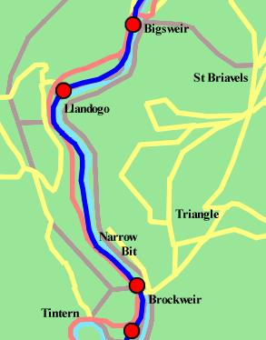
Map not really to scale.WVR in dark blue. Proposed stations marked by red dots, none of which are currently open. Footpaths in brown (proposed and in place). Local roads in yellow. Major roads in red. Water in pale blue. North at top. The next length of line heads north from Tintern station through Brockweir and Llandogo to Bigsweir, although for most of its career the station at Bigsweir inferred to passengers that it served the village of St Briavels on a hill to the east. Along the way the route takes in some 3½ miles of delightful riverside running including a rather awkward narrow bit where the road will need shifting back off the railway line. |
|
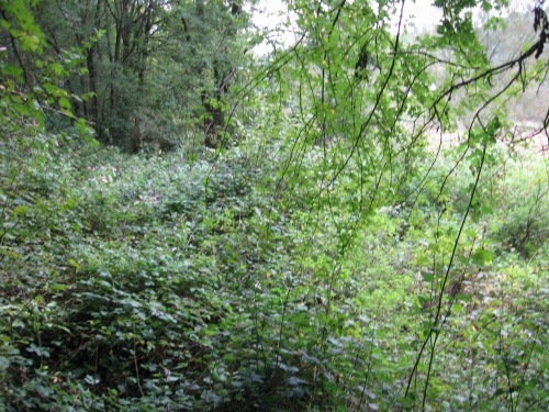
Brockweir Halt
|
Brockweir Halt was built in 1929 on the north side of the approach road to the Brockweir Bridge. It was an extremely convenient little platform, on the left of the picture, which offered direct interchange with the competing bus service by means of the bus stop at the top of the approach path. Since closure the site has become overgrown, the platform has vanished, the road overbridge has been filled in and the A466 has been widened. The last of these is not a massive issue just here, although it becomes more awkward for a ½mile or so further north. The overgrowth can be fairly readily cleared away to reveal a nice open site overlooking the Wye on which the new platform can be built. This would come with an attractive (if basic) open-fronted brick shelter, a couple of benches and some lights, information boards and so on. The space off to the right would make a nice picnic area - there's enough room under the bridge alongside the Wye for an access path (presumably left as floodplain) but it would be preferable for aesthetic, practical and environmental reasons to leave it as plain grass with no surfacing. The bridge would have to be excavated again to allow the railway to pass beneath the road. There is something of a shortage of pictures showing Brockweir Halt looking south so whether this bridge was an arch or a girder is unclear. If it was an arch, it's probably just been infilled and can be excavated fairly easily. If it was a girder, the girders will have been removed and the gap nicely packed full of earth. Digging it out again would entail a week-long closure of the main road into Brockweir and the only road crossing of the Wye between Bigsweir and Chepstow. The local authority will probably sneer at our pleas that the railway was there before the road and accordingly the works should be carried out at the expense of the Monmouthshire roads budget. Paying for the road possession will therefore be a bit expensive. Brockweir residents will be compensated with apologetic leaflets and two weeks of free rail travel after the line reopens. |
|
|
|
|
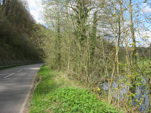
Riverbank north of Brockweir
|
This is the awkward bit - a particularly narrow section of the valley where until 1875 the hill slipped almost straight down into the river with a narrow turnpike road clinging to its flank. The railway left a rather deeper scratch in the hillside just above river level where the trees in the centre are today. After the railway closed the road was improved, with the scratch into the hillside being deepened and some economy being exercised by liberally recycling the railway trackbed. Our preferred option is therefore to slightly narrow the road and place the railway on a six-foot-high ten-foot-wide wall along this length. This would ensure that anyone who leaves the road writes off their car without substantially disrupting rail services. The sheer wall into the river should be solid enough to avoid too much trouble from the Wye, which will if necessary be slightly widened on the other bank. While road users will lose their view, you can't see much through the trees anyway. Rail users will get a great view and the wall will help deaden the road noise. If the road noise is still too annoying it would be possible to raise the left-hand side of the railway's wall a bit and put a roof over the road - the hideous monstrosity that would result would be marketed as an avalanche shelter. With hourly electric trains the rail noise would be pretty minimal (a low rolling roar for about 2 minutes out of every 60 - noticable at first, but easy to get used to). An alternative cyclepath around this section would be organised at the top of the cliff to the left to allow walkers and cyclists to avoid this unpleasant artificial cutting. The whole lot could be made more decorative by moving the road 10ft to the left and putting it in a nice landscaped cut-and-cover tunnel with the railway round the outside, but that would cost millions and close the road for six months. |
|
|
|
|
Llandogo Halt
|
This was the second halt to be opened on the WVR (in 1927) and one of the last two to disappear - its halt platform, along with Netherhope's, survived into the 1970s. It is now a parking area for an adjacent house. The halt shelter survives - possibly uniquely for the six halts - as part of a shed on a private field by Llandogo churchyard. (Wanna wanna.) There will be a general assumption here that the houseowner wants to keep their drive despite the convenient nature of a station with an hourly train service between Cardiff and Monmouth. (They may have strange ideas about going to Coleford, which the WVR unfortuately won't help with.) The railway will therefore be moved 8 feet to the left into the adjacent field - ruining a lovely bit of curvature, but making the compulsory purchase orders a bit easier to work through. The original platform was on the right-hand side of the line. Its replacement will be on the left for reasons of general convenience. The building will be another open-fronted brick affair. The railway here is very convenient for the church, local shops, pubs and so on. The village is scattered up a steep hill which we can't do much about, so the houses at the top will not be very far from the station as the crow flies but will still end up with a long and tiring slog up the hill from the station. (You won't get used to it as easily as the noise of the train, although the higher up the hill you get the less distinguishable the sounds of the train will be from the road noise and accordingly the less likely it will be that the railway will bother you. Instead it will tidy up a rather messy bit of hedge that stretches around a couple of nice curves to the north of the village.) |
|
|
|
|
St Briavels
|
St Briavels station went through three names - it began as Bigsweir, became St Briavels and Llandogo and settled on St Briavels shortly before the opening of Llandogo Halt. Bigsweir was the most honest of the three, since the station is adjacent to Bigsweir and its famous (and attractive) bridge while St Briavels is a mile away up a steep hill. In fact, barring a cluster of farm dwellings on the other bank of the river, the nearest habitation is a mile away; St Briavels Road would have been the ideal post-1927 name. This lack of nearby development explains why the station closed to all traffic in 1959 along with the halts and Tidenham. Unlike Tidenham, there would be no reprieve for quarry traffic. On the plus side, the rural nature has allowed the main building and goods shed to survive, though the goods shed is looking a little poorly. Re-opening would be a simple matter of repairing the platform and re-instating its edging slabs. A loop would be helpful but not essential; there isn't really enough room between the original platform and the goods shed (which we want to keep) for a second platform here. The old goods yard, to the left and centre, will make an excellent car park; the station would probably be branded either as St Briavels Road or St Briavels Parkway. Currently the station is being used by a fishing group. They need not be concerned about the station being re-opened. Passing trains will provide an additional level of security with train crews to keep an eye on the place. The re-opening would involve giving the place a coat of paint and refurbishing the goods shed before the roof falls off. It is quite normal these days for old station buildings to be privately owned and run wholly independently of the railway; if the fishing group want to maintain some station gardens, sell tickets and offer refreshments to passing tourists there will be no objections from the railway. Traffic levels are unlikely to be high enough to case a disturbance. Credit should be given to the fishing group for allowing us to take this picture of their private site. |
|
|
|
|
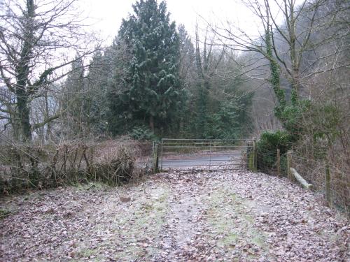
St Briavels Level Crossing
|
St Briavels level crossing, one of only two on the line (the other was at Whitebrook and rapidly lost its importance; there was also a crossing at Bishton in the early months of the line's career pending the construction of the infamous bridge), is a bit more of a problem. Once upon a time the A466 at this point was a single track road, rather like the railway; it came off Bigsweir Bridge (to the left), ran over the railway and joined the minor lane from Whitebrook off to the right. After closure the road was realigned, regraded and widened; this process resulted the the unfortunate demolition of St Briavels signal box. It will also have to be partly reversed in order to put the level crossing back in for the railway. (A road overbridge is an option, but it would make access to the station difficult, involve raising all the approach roads by 20ft and take months, so we'd rather not if it's all the same to you.) The problems of lowering the main road can be eased slightly by raising the railway a bit, but this is limited to raising it by about a foot (limited by the proximity of the station and its already slightly low platform). The road will have to come down by about two feet. The width of the road shouldn't be an issue except for the fact that it will mean rather tall crossing barriers. (Not to worry; they'll probably end up being hidden by trees when raised.) The close proximity of the narrow river bridge means that installing the crossing's Stop lights won't seriously extend road journey times; the two sets will be wired together to minimise traffic flow problems. Whether we end up with a crossing protected by "wig-wag" lights or standard traffic lights is more a matter for debate. Unfortunately re-opening will entail removing the rather nice conifer on the other side of the road, which is growing in the middle of the line. |
|
|
|