|
|
|
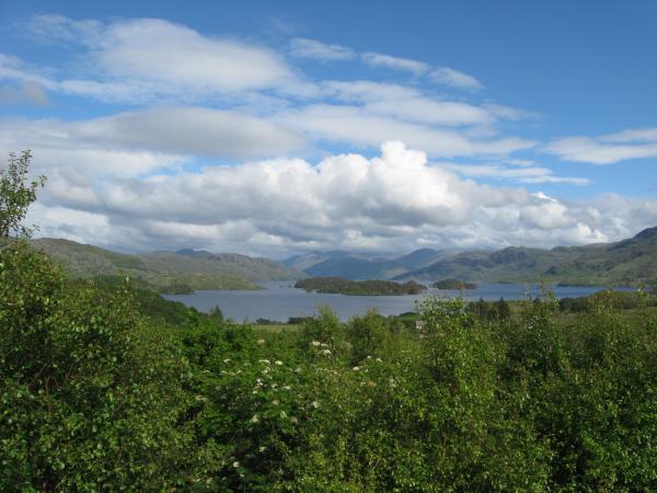
This is probably because other, more democratic countries have laws against being as beautiful as Morar when some people have to live in unattractive cities. Morar is the name given to a river, a village to the north of the river and the loch that the river flows out of. The village is attractively situated on the old Road to the Isles, though has now been bypassed. It is in the sort of completely rural location where warning signs have to be put up reminding motorists how zebra crossings work. The road gives out three miles further north on the farther side of Mallaig, port for Armadale on Skye, the Small Isles of Eigg, Muck, Rum and Canna and the one-road town of Inverie on the Knoydart peninsula, which notoriously has no road access despite being on the British mainland. The ferry from Mallaig to Knoydart extends onwards down a sea loch to the two dwellings (and small castle) that make up Tarbet, a beautiful spot beneath waterside mountains and a narrow ridge that separates it from Loch Morar. A path runs up the ridge and then follows the north bank of the loch back to Morar villages. It is five miles to the surfaced road and a further four to Morar itself. Along the way are a lot of derelict sheepfolds, a couple of abandoned churches, some isolated trees, views of the small wooded islands in the loch and a remarkable feeling of total isolation. The loch is the deepest in Scotland (and the deepest body of freshwater in the British Isles, at 1,017ft), nearly 12 miles long and filled by 2.3 cubic kilometres of water (the equivalent of 4,047,432,500,000 pints, which means that if it all turned into milk and was sold in 4-pint bottles it would be worth around a trillion pounds). It is home to trout, Atlantic salmon and a monster called Morag. The River Morar flows out of the north-western end of the loch, through a hydro-electric power station, under a rather fine concrete railway bridge and into the sea in Morar Bay, which feeds the Sound of Sleat. Morar Bay is noted for its beautiful white sands; on a warm day it is a remarkably pleasant place to sunbathe and benefits from a peaceful, largely enclosed setting. The bypass makes it a trifle more long-winded to access from Morar itself than before, but also takes what little traffic there is off the rural byway that represents the old road between Morar and its Silver Sands. The picture was taken from a fine lump of rock that stands above Morar and means that from the village itself there is no view of the loch, although several straggling houses offer splendid vistas of this broad expanse of water in the setting sun. The rock was once used as a meeting place for religious groups and a cross still stands on the summit. It is also a good point for watching the trains ambling around the curve into Morar station on the last leg of their journey from Fort William through Britain's most westerly station at nearby Arisaig to Mallaig (although there are rather a lot of such good points hereabouts). Morar is, as the poet quoted to bookend this piece remarks, a very soothing location for the tired person in need of a general break. It is, however, particularly chosen this month in light of the unexpected news of the sudden and unfortunate death of the late Member of Parliament for the area, the Right Honourable Charles Kennedy, a little over three weeks after his loss of the seat in the 2015 General Election.
(With additional words from the poem "Silver Sands of Morar" by Angus MacLellan.) |