Those people who are familiar with
this website will be surprised by the sudden appearance of a helpful
navigation bar at the top of the screen. It's part of a scheme
to reformat the website and make it easier to navigate. Seasonal
Area gets uploaded by the month rather than whenever the Planning
and Engineering Departments can knock something out, so this page
is going out with the bar and before the rest of the site has
been organised. We apologise for any issues which may be encountered
during the changeover and hereby blame the lazy and dysfunctional
nature of our pro-bed organisation.
(Incidentally, anyone who knows the
practical differences between .htm and .html file extensions -
other than the missing "l" in the former/ additional
"l" in the latter - is cordially invited to find the
Contact link - wherever it ended up, we don't know, we're still
not getting one - and explain to whoever reads our emails what
said differences are. Several of the departments have been given
wholly new pages and consequently have managed to be changed from
.htm to .html, which means re-doing half the links around the
site. For some reason the Wye Valley Railway section is also getting
another massive overhaul which will involve even more of a re-write
than last time, so prepare to be confused when several pages start
talking about something else and the Department of Comment, Satire
and Tripe take on the spare page numbers. Several departments
have also been renamed for good measure; rest assured that nobody
plans to notice. Meanwhile strange and probably untrue rumours
are circulating that someone has been asked to finish writing
page 27, which has been lying around on the "to do"
pile for some 8½ years.)
Right, to business. This month we have
another image from 2010, derived from a cycling trip between Pontypool
and Abergavenny (via Usk, Monmouth, Garway and Pontrilas) which
the Planning Department organised for a thrilling day out to trace
one dead railway and four railways that were never built. Between
supporting the local economy (by buying half-pints of lemonade
in rural pubs) and terrorising traffic (by cycling along paying
more attention to where the Monnow Valley Railway was going to
go than to where the Osbaston Road does go) the Official Photographer
took lots of pictures of various bits of unspoilt scenery, idyllic
ruins and the A449 expressway. After the Planning and Railways
Departments had taken their pick of the most relevant of these
the surplus images were dumped in the archive; this one was plucked
from obscurity because it looks nice and as there isn't a railway
in shot we can't see either department ever finding a use for
it.
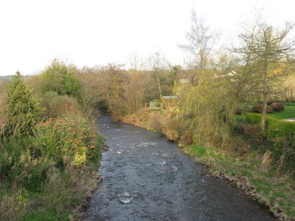
It shows the Afon Honddu, which can
put in a sort of claim as the last river in Wales - the next one
to the north, which the Honddu joins a couple of miles downstream,
is the Monnow, which currently represents the English/ Welsh border.
Here it is seen tumbling past Llanvihangel, which is a charming
village that the Photographer neglected to examine further. Abergavenny
was only seven miles away and he'd been on the road for almost
9 hours by this point. But we're sure it's worth a visit.
The Official Photographer is apparently
concerned that he's going to find out what Llanvihangel is like
when the Railways Department decides to run the trip again for
some more pictures of Garway, an improved photo of the Monnow
Valley Railway at Grosmont and another few pictures of Skenfrith,
which they think may hold some kind of record. At least five proposals
were drawn up for railways through Skenfrith but none of them
were ever built. There remains some confusion as to how you take
a picture of a railway which doesn't exist, but the Railways Department
thinks that such pictures encourage thought and understanding
of something.