|
While the Wye
Valley as a whole is beautiful (possibly except for some of its
wetter bits) for all its journey from Plynlimon to the mouth
at Chepstow, what is normally defined as the Wye Valley is the
thirty mile long section from Ross to Chepstow, leading through
rugged gorges and thick woodland out of the busy streets of Ross,
round long bends past the slightly industrial village of Lydbrook
and a nearby factory, past Symonds Yat, through picturesque Monmouth,
past Redbrook, former home of a little tinplate works, around
Tintern and its Abbey, and then through gorgeous valleys and
signs of quarrying to Chepstow Castle and Chepstow itself before
pouring into the Severn estuary. Throughout, there is one constant
developed to a degree not seen elsewhere: magnificent, incredible,
natural beauty. The whole valley has the air of one river –
the Wye. |
|
At Ross on
Wye the Wye leaves a direct North-west to South-East route that
would bring it into the Severn near Gloucester and turns South,
curving as it strikes the rock on which Ross-on-Wye is built.
From here it slips smoothly onwards in the green fields which
it has left just enough room for up to this point. From here
the Wye will leave less room for other developments, and for
much of the rest of its course it will care only for itself.
We follow the journey from the point of view of a boat or log
following the Wye.
Upon turning
south, we pass between green fields in a relatively unpopulated
area where the Wye flows quickly southward. The valley is broad
and merges into the surrounding countryside. We move from Gloucestershire
to Herefordshire as soon as we leave Ross, but there is no immediate
change in scenery.
 |
|
The Wye runs
through fields at the bottom of its sloping valley, winding slightly
and running practically on the level. Several surrounding fields
lie under plastic tunnels to protect their crop, which is mostly
strawberries. The railway from Ross to Monmouth – closed
in 1959 to passengers and in late 1964 to freight – joins
us along here as it drops down the hill from the former station
behind Ross-on-Wye.
 |
|
The change
comes rapidly though. We pass under Kerne Bridge – now the
last crossing place for about 3 miles – and the old railway
station of the same name – now a private house. Goodrich
Castle stands on a hill to the west. To the east is the Forest
of Dean. The river curves swiftly round to the left, slightly
north of east, passes the site of the old Ross and Monmouth railway
bridge, and runs past some caravans forming temporary housing
which looks permanent on the left. The railway dived into the
large hill on the right, which has Welsh Bicknor at its peak.
Now we share the valley solely with the road. After about a mile
and a half, we round a curve, and sweep southwards and to the
southwest as we pass Lydbrook.
 |
|
Lydbrook is
on the left as we head downstream, an attractive little industrial
town served by a mixture of very minor roads – none classified
– practically from nowhere. The Severn and Wye Railway built
a branch to here, amounting to a little single track line which
spanned the Lydbrook valley on a large three-span viaduct at
the mouth of the valley where it meets the Wye – the second
most impressive structure on the Severn and Wye network after
a bridge over the river Severn, but now long demolished. The
railway provided stations at Upper Lydbrook and Lower Lydbrook
from its opening in 1875, but traffic was never healthy, and
what remained of the limited service had faded by 1956. Passenger
trains ended in 1929. Lydbrook still presents a reasonably healthy
image however.
A short distance
downstream the Ross and Monmouth Railway bursts back out of the
hill and passes the Edison and Swann Wireworks which, after keeping
rail traffic going from here to Ross until 1964, now attempts
to look derelict, despite expansion since then. A set of marks
on the wall advertise flood heights over the years, taking the
Wye about 20 feet above normal at best, and the viaduct remains
intact as the sole place to cross the Wye between Kerne Bridge
and Symonds Yat. The junction between the Ross and Monmouth and
the Severn and Wye Railway has gone forever, and the site is
now an industrial factory in the middle of nowhere, surrounded
by fields and the Wye.
 |
|
The river and
railway join forces from here, even if now only an abandoned
trackbed keeps the river company as the countryside grows more
impressive and ever more beautiful. There is little habitation
for miles, there are few roads, the hills steepen, and the fields
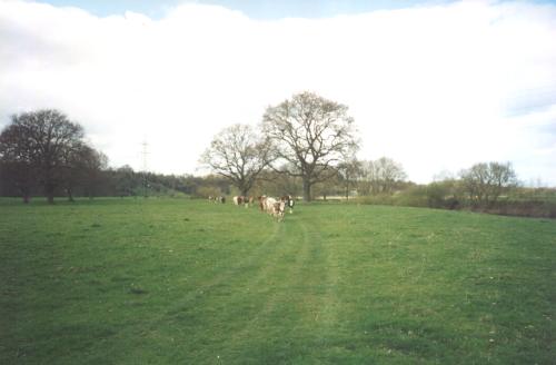
are quiet, inhabited only by a few herds of cows.
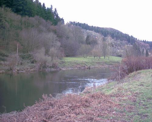
This is one
of the more lovely spots in the country, and people have died
proving its beauty. Many years ago in the 19th century a Portuguese
boy came in summer with his family – a relatively well-off
group with four children. The boy went for a swim in the "treacherous
stream", flowing smoothly and beautifully onwards –
however good his swimming was, it was not good enough to save
him. He was drowned – a memorial marks the spot, conveniently
sited just where people will decide that a swim is a good idea
hereabouts.
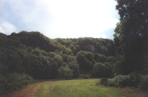
The Wye sweeps
onwards, and the east bank rises into an abrupt cliff –
the railway sweeps around the bottom, a scratch on the riverbank.
Then it plunges into a tunnel as the Wye curves onwards, now
heading north, albeit briefly.
 |
|
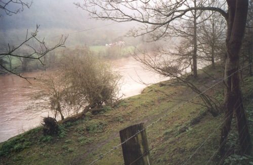
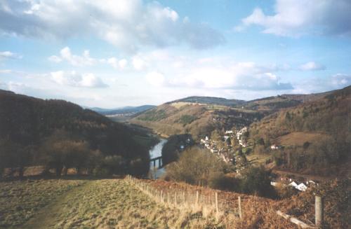
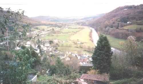
The river sweeps
into an enormous meander around Symonds Yat rock, but things
even out briefly and a more gentle landscape appears around the
river as it curves south, under another road bridge. There is
only one bridge left between here and Monmouth – Monmouth
is seven miles away.
The river,
after a brief respite, returns to the bottom of the Symonds Yat
rock, with the former station almost overhanging the river. A
little island sits in the middle of the river while we sweep
onwards, first westwards, but turning south to Monmouth. A footbridge
crosses the river and paths go along both banks here – one
on the bank (west) and one on the old railway (east).
The trees end
a few miles south of Symonds Yat as the landscape becomes gentle
enough for cultivation. Fields begin to cover both banks, though
now with some crop growth as well as animals. A road of sorts
appears on the east bank as we leave the woods – a narrow
lane heading for Monmouth. It will link up the various farmhouses
along the way and compete with the railway for limited space.
The A40/A449
found a quicker, more hilly route over the top and sweeps down
to join us as we finally return to a southwards course. The valley
narrows slightly and returns to being wooded. We cross the border,
leaving England and Herefordshire and entering Wales and Monmouthshire.
 |
|
The narrow
form does not last long as the west side widens out to allow
for the confluence of the Wye and the Monnow. This leaves enough
room for the county town of Monmouthshire, Monmouth, to lie on
the rolling landscape, facing down at the Wye and standing above
the Monnow. The riverfront is dominated by the fast road. An
industrial estate sits on the old railway and the station of
Monmouth (May Hill). A canoe launching/landing point is on the
right. The A466, carrying traffic for the Forest of Dean and
the Lower Wye Valley, crosses us on a stone bridge. The next
road bridge is 6 miles away at Bigsweir. Monmouth Boys' School
sits beyond the road on the right, attempting to appear unperturbed
by all the noise.
The river rapidly
leaves the road, moving east to a confuence with the Monnow,
under the Ross and Monmouth Railway and then past the old Wye
Valley Railway viaduct. Above us on the left is Wyesham and the
Kymin while on the right the Wye Valley and Ross and Monmouth
Railways meet under the Gibraltar Rock in Monmouth (Troy) station
– closed to all rail traffic for over 40 years. The Rock
is bored under by the Coleford, Monmouth, Usk and Pontypool Railway
as it proceeds to Pontypool and also by the dual carriageway
as it heads south to Newport.
Shortly after
the hillside on the left becomes steeped and more wooded again
while the gentler slopes of the right bank are taken over by
agriculture. The Trothy also eases in from the west in a small,
easily missed confluence.
 |
|
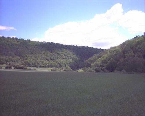
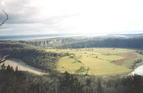
After this
point the Wye enters a more steep-sided valley – while the
west bank remains more easily graded than the east, it is not
gently-sloping by any means. Penallt is visible three-quarters
of the way up the hill, and we proceed onwards to Redbrook. The
west bank is mostly given over to large green fields. From the
bottom, the east bank has the river, the Wye Valley Walk, the
A466 en-route to Chepstow, the Wye Valley Railway, the steeply
ascending Coleford branch (both dismantled) and a few paths on
top of the hill, including the Offa's Dyke Footpath. These, and
a few stray deer, are all hidden behind trees.
 |
|
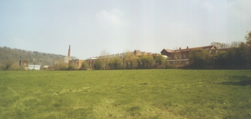
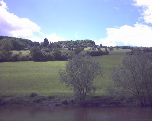
Formerly the
industrial centre of this part of the valley, Redbrook is now
an attractive village built around several ruined tinplate works.
One of the roads into this village (of which there are only four,
and one doesn't go very far) has an old incline dropping over
it; a lane from here has some kilns on one side, and until recently
there were several abandoned buildings at the southern end of
the village – however, the place is expanding steadily and
these were pulled down to make way for more pleasing housing.
While not a supporter of wanton destruction of everything in
sight of no further immediate use, Redbrook does not advertise
its past with guided tours, and makes use of the incline bridge
and surrounding trees overhanging the A466 to impose a height
limit of about 11' 6" on all things passing through –
it is, therefore, not plagued by juggernauts and tourist coaches,
but is a pain to move to. The English-Welsh border joins the
river here, resulting in the west side of the river being in
Wales from now on. So is the most northerly house in the village,
by virtue of the fact that the border does not bother with going
around the outskirts of the place.
 |
|
The Wye Valley
Railway crosses the Wye, skirts around the roof of the Boat Inn,
and vanishes into the trees. We move into another section of
the valley with thick tree growth on both sides, with the A466
at the bottom of the hill on the east side, the Wye Valley Railway
on the west side, now in the form of a track, and a few roads
and houses on the west side of the valley. The Wye heads south
to Whitebrook.
 |
|
Whitebrook
is located on a small tributary which joins just before the Wye
swings into a small meander. The English east bank remains wooded
– the Welsh west bank loses its tree cover and turns into
green fields. The railway is hardly more visible now than it
was when hidden by trees – it has been ploughed into fields
and quietly disappeared, while the road from Whitebrook to Bigsweir
swings around above it.
The landscape
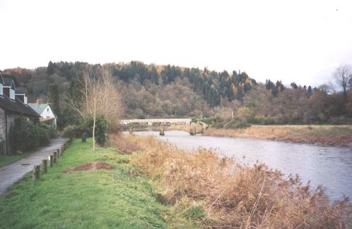
stays pretty much the same until just north of Bigsweir. Here,
the hills on the west become steeper, with trees growing over
most of that side of the valley, while the east bank becomes
a bit gentler and turns into rolling farmland. A road drops down
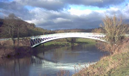
from the large village of St. Briavels to join the A466 and a
very old narrow iron bridge of 18th century origin spans the
river in a graceful manner. It is now protected by traffic lights
with a bricked-up tollbooth no longer charging for its use.
 |
|
There is now
nothing other than farming and a footpath, while the road from
Whitebrook joins the A466 on the west bank and squeezes past
the old station here before climbing around the hillside –
road, dismantled railway and river all squashed against one bit
of hill while the sheep and cows in the broad pastures on the
other bank look on.
The river flows
onwards, with trees appearing on the east bank again while the
west bank widens into Llandogo. The road, railway and river spread
out again with some fields around the outskirts of this village.
The hill rises steeply up to the west, with the village climbing
halfway up the slopes.
 |
|
The valley
narrows again, with the railway running along the bank and the
road a little way off up the hill, with a few houses interspersed
along the way. The valley narrows a little as we approach Brockweir
and the road extends out onto the railway trackbed. The west
hill is mostly covered in trees, while the slopes of the east
bank are covered in fields.
 |
|
Brockweir bridge
was built in 1906; its backers promptly ended up fighting a court
case against a local ferry owner, who was terrified that it would
put him out of business. It did, and the ferry has gone, but
the bridge remains, albeit a little out of place on the Brockweir
side with a steep gradient into the village with its little Moravian
church – burial place of, amongst others, the author and
Girl's Own editor Flora Klickmann, who wrote several articles
on the Wye Valley and her cottage nearby.
The river sweeps
west and passes between two abutments marking where the railway
passed over the river and plunged through a spur to the south
in a short tunnel. Tintern appears on the west bank as we sweep
around to the other side of the spur and pass under the old railway
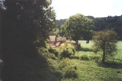
bridge to the former Tintern Wireworks.
 |
|
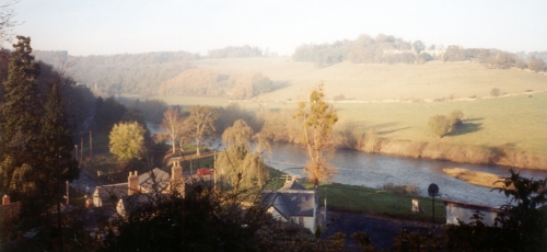
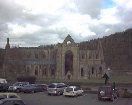
Tintern village
is now about the same size as Redbrook, but has more tourist
attractions. The visitor economy is particularly buoyant and
the car parks are of better quality. Tintern Abbey and the Old
Station gain the most visitors, so to a certain extent it is
a little ironic that in order to provide a rail service to bring
visitors in from the North one of the area's tourist attractions
would have to be heavily modified to take a through line en-route
to Chepstow. There are also a large number of shops in Tintern
village centre. The Abbey, however, is undeniably the major attraction
of the Wye – one of the few in Wales, and the main building
only lacks roof and glazing, although this is a pain if it starts
to pour with rain in the middle of a visit. Here the Angidy river
flows down from the west – the last river of any importance
to join the Wye.
 |
|
River, road
and railway now run straight south with the river dropping gently
down. The road climbs away on the west bank and starts to sweep
up the hillside with some unpleasant curves on the steep hillside
under the Wynd Cliff. Opposite, the railway climbs a more sedate
gradient. The river takes a fairly straight southerly route.
As the road
curves away and the railway finds itself high above the river
we enter the industrial area of the Wye, with a large open quarry
on the west bank, digging under the road yet invisible from it.
It is complemented by a larger disused quarry on the east bank
above the railway. Both extract limestone.
As the river
passes the quarries it swings round to the west. The railway
promptly plunges into Tidenham Tunnel while the A466 hops over
the top of the hill on the west, leaves the valley, and heads
off to St Arvans. The river starts to curve around to head east
in a large meander with a steep wooded hillside on the outside
of the curves. The inside is more gradual, sloping down to the
water, and the east bank has some fields on it and a small, remote
farmhouse.
 |
|
From the meander
the river sweeps on past the bottom of the 200ft high Wintour's
Leap, off which Cavalier Sir John de Wintour is supposed to have
leapt on his horse while being chased by Roundheads during the
Civil War of the 1640s. The fact that he is supposed to have
survived is just a little iffy. However, Wintour's Leap is soon
past as the Wye pours on southwards before curving briefly to
the east when it touches the rock on which Chepstow Castle is
built. The trees end here and we enter Chepstow. Then the river
curves round to the south again at the bottom of another large
cliff, passing under the old road bridge – guarded by traffic
lights owing to its narrow nature – and follows that up
with the current A48 bridge and the railway from Gloucester.
The land starts
to fall down to river level on the east bank, while on the west
are the railway and some large cliffs. The Severn becomes visible
on the left flowing down from Gloucester as a massive expanse
of water. The west bank flattens out and the land between the
Severn and the Wye becomes flatter and marshier. We pass under
the Old Severn Bridge, or the First Severn Crossing, carrying
the M48 across the rivers, and then we enter the area where the
Severn and Wye are only split at low tide. A small ruined hut,
formerly owned by a hermit, sits just above water level as a
marker of the end of the Wye as it joins the Severn and their
muddy waters sweep around together into the west and the sunset
along the South Welsh Coast. |
|

%20JPG.jpg)